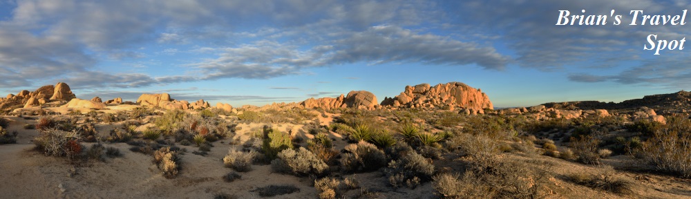
 Welcome to The Grand Adventure, the latest in the occasional Brian’s Travel Spot series, which document my various travels. This is part of a wider trip which I took in January/February 2017, the first two parts of which covered my first visit to Phoenix in October 2016 and my return in January 2017. This post marks the start of The Grand Adventure itself, a road trip that would ultimately see me driving over 1,200 miles, starting in Phoenix and ending, almost exactly seven days later (to the hour!) in San Francisco.
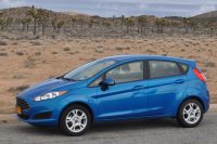
However, I’m getting ahead of myself. After spending a week in Phoenix, where I was attending a four-day business meeting, I set off in my hire car, a rather striking blue Ford Fiesta, to drive west to Los Angeles, via the Joshua Tree National Park. After a day in Los Angeles, the plan was to drive north along the California coast, mostly along State Route 1, the Pacific Coast Highway, with several stops along the way, ultimately ending up in San Francisco.
This post, Part I of the Grand Adventure, covers my drive west from Phoenix to the Joshua Tree National Park, where I arrived on the evening of the following day.
I’ve split this post into four parts:
- From Phoenix to Wickenburg
- Wickenburg to the Parker Dam
- Parker Dam to Twentynine Palms
- Sunset in Joshua Tree
You can see how the drive to Wickenburg went after the gallery.


")


 1
1 2
2 3
3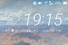 4
4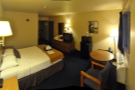 5
5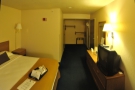 6
6 7
7 8
8 9
9 10
10 11
11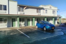 12
12 13
13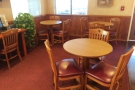 14
14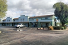 15
15After a week of relatively good weather in Phoenix, I set off on Friday night after the end of my meeting in an almighty rain storm. This was the tail end of one of a series of storms that had been battering the Californian coast for the previous two weeks, bringing torrential rain and causing a lot of damage and disruption. Fortunately for me, by the time the storm reached me, it was relatively mild. It didn’t really affect the drive, but it did rather ruin the prospect of any decent views along the way.
My ultimate target in the first stage of my drive was the Joshua Tree National Park in California, a mere 280 miles due west of Phoenix, or to put it another way, around five hours of driving. In the dark. After a full day at work. So I decided to break my journey in Wickenburg, 60 miles, or about an hour’s drive northwest of Phoenix. Well, an hour’s drive on empty roads. Without the rain. More like 90 minutes on Friday evening in the rush hour. On a road system that really does not cope well with rain.
That said, the drive was pretty straightforward. As I’ve said before, navigation in the US is relatively easy: I had a list of four roads pinned to my dashboard: 101 (west), I-17 (north), 74 (west), 60 (west) and that was it. Just follow the sign posts when you reach the junctions. Once I had negotiated the log-jam that was 101 (think M25 in the rush hour for UK drivers), the traffic was free-flowing and I made good time to Wickenburg. I suspect that there were some good views along the way, particularly along Highways 74 and 60, but due to the rain, I didn’t get to see very much (I did repeat the route in 2020 and the views were indeed very good).
My hotel in Wickenburg was a Super 8, a basic motel, which did the job given that I was there for just one night (and, in a neat display of symmetry, my last stop before San Francisco was also for night only and in a Super 8 too!). In its favour, my room was spacious and comfortable, the free Wifi worked and the breakfast room was pleasant and spacious (which is not always the case in the US), serving a free breakfast of toast, cereals and pastries. The other thing that the Wickenburg Super 8 had going for it was that there was a Denny’s across the road.
Denny’s is one of my guilty pleasures. For those not in the know, Denny’s is a nationwide diner chain which I have a soft spot for, having visited one on my first ever trip to the USA back in 1998. I make no great claims for the quality of Denny’s, merely that it is a consistent provider of the sort of comfort food which I love. Normally I go there for breakfast, or pancakes (often, not but always, at the same time). However, on this occasion I went for dinner and had a very fine omelette.
When it comes to Wickenburg itself. I can’t really tell you very much about the town. I was there for one night, arrived just before nightfall in a rain storm, and what little I saw of it was on the drive down the main street when I set off the following morning. That said, I did visit Wickenburg again in 2020, when I had a couple of hours to look around, finding a very pleasant little town, very much trading on its Wild West heritage.
You can see what I got up to on my drive to Joshua Tree after the gallery.


.")
 just before it empties into Lake Havasu.")


 side of the lake...")


 so I stopped at this little diner.")


 but impressive Parker Dam built in 1934-38.")


 1
1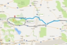 2
2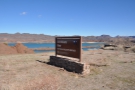 3
3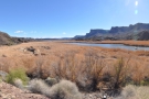 4
4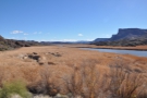 5
5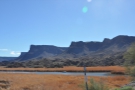 6
6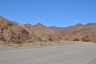 7
7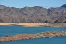 8
8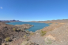 9
9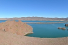 10
10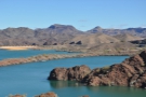 11
11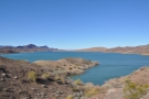 12
12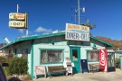 13
13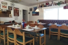 14
14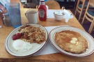 15
15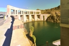 16
16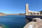 17
17 18
18There was more rain overnight in Wickenburg, but it had cleared up by the following morning, leaving me with blue skies and the prospect of a great day ahead. Even so, I still set off later than I meant to (a common theme for the rest of the week: I am so not a morning person).
A word about driving. I am not a huge fan of driving. I don’t mind it, but I can’t say I enjoy it, particularly not in the UK, where the traffic often makes it stressful. For me, it’s still just a method of getting from A to B and I can’t wait for the advent of driverless cars. This trip is a good example. Even though the driving and navigation were easy (generally, get on the road, point the car west, set cruise-control and go) every stage would have been improved had the car driven itself.
While the drive was straightforward and there was virtually no traffic, the requirement to keep the car on the road seriously hampers my enjoyment. I want to look around, take photos, soak in the landscape, all things I can’t do when I am stuck behind the wheel. I felt I saw so little of the environment around me compared to what I would have seen had I not been required to drive.
My destination, Twentynine Palms, on the northern edge of the Joshua Tree National Park, is about 200 miles due west of Wickenburg across the Sonoran Desert, or 220 miles if you stick to the roads (highly recommended). The total drive is, according to Google, 3½ hours, which is a little too long for me in one go without a break. I had two potential routes, both starting with US 60 (West). I could then either drop down to I-10, the main east-west interstate, which would add another 20 miles to the journey, although not much more time, or I could take a more north-westerly direction along SR 72 before joining US 95 (North) to the town of Parker, near the Arizona/California border.
I went for this second route because it gave me more options to break my journey. Depending on how tired I was and how well the drive was going, I could stop at Parker itself, or carry on north on US 95, up the Colorado River to Lake Havasu and the Bill Williams River National Wildlife Refuge. This would put another 20 miles each way on the drive, and probably an hour of driving, but give me a chance to see some dramatically different scenery, including the Parker Dam, one of several hydroelectric dams on the Colorado River and the one that’s responsible for Lake Havasu.
The early part of the drive was uneventful. US 60 is like a major (UK) single-carriageway A-road, while SR 72 was clearly a less well-travelled route (I drove the full length of SR 72, all 37 miles of it). On both roads, I hardly saw any other traffic, and the towns I passed through along the way were hardly major (there wasn’t a town with a population of over 2,000 people). It was just a case of set cruise-control, put on some podcasts from the wonderful Penny Dreadfuls Show and admire the scenery.
For most of the journey, I was following the line of the Arizona and California Railroad, a freight-only line. Sadly I did not see any trains along the way. The landscape is (to me) very alien; flat, desert scrub, with sudden, distant mountains (which came a lot nearer at the junction with SR 72). It was also unexpectedly green. Not verdantly green, you understand, just that there was a lot more plant-life than I was expecting. On the other hand, it was January, the temperature was in the mid-teens (⁰C) and the area had just had quite a bit of rain. I was probably seeing it at its least typical. That said, I doubt I would have enjoyed the summer heat…
All this dramatically changed when I got to Parker, a town of some 3,000 souls which felt a lot bigger. Suddenly the highway became multi-lane and I swung north along US 95, which was a modern, three-lane highway as it climbed out of Parker, following the line of the river with some dramatic sweeps and curves. Slowly it dropped down to two lanes, then one, and I found myself driving along the southern edge of Lake Havasu (a reservoir). After two hours of desert landscape, it was a real shock to be back where water, and water erosion, dominated.
My turnaround point was where US 95 crossed the Bill Williams River (the closest I’ll get to having a river named after me!) as it flowed into the eastern end of Lake Havasu. From there, I went back, had lunch in Parker Dam at a lovely, little diner, then went to see the dam itself, built between 1934-38. I would have liked to have driven down western (Californian) side of river, along the winding Parker Dam Road, but I was short on time, so went straight back down US 95.
You can see how the last part of my drive to Twentynine Palms went after the gallery.


 1
1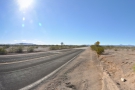 2
2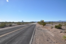 3
3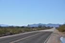 4
4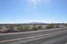 5
5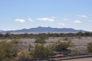 6
6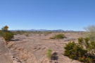 7
7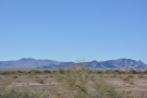 8
8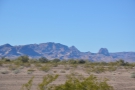 9
9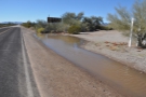 10
10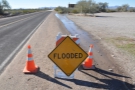 11
11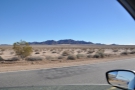 12
12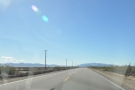 13
13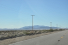 14
14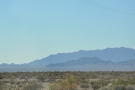 15
15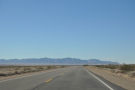 16
16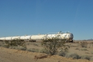 17
17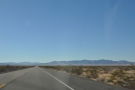 18
18 19
19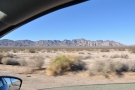 20
20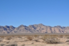 21
21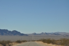 22
22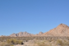 23
23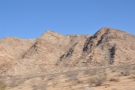 24
24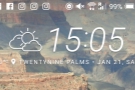 25
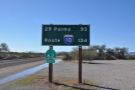
25From Parker, it was pretty much due west to Twentynine Palms, the northern gateway to the Joshua Tree National Park. Just after Parker, I crossed the Colorado River and entered California, turning left and following SR 62. Not long after that, SR 62 crossed SR 95 going north at Vidal junction. There wasn’t a lot there, except for a Californian highways inspection point where I was obliged to stop, so I thought I might as well get out and have a look around.
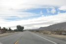
It was the first time that I’d actually been out in the desert landscape that I’d been driving through. Having grown up with tales of the Sahara, desert, in my head, still means endless vistas of shifting sands. Despite having seen numerous westerns and many more films set in the southwest of the USA, I’m still surprised when deserts aren’t sandy.
The landscape here was very typical of that I’d been driving through: flat, with interesting mountains on the horizon in every direction. Nearer to hand, there was plenty of scrub and a small tree or two. There was also a good deal of water from the recent rainstorms: looking at how much water was left standing by the side of the road, I was very grateful that I hadn’t been doing this drive the previous day, when I suspect I would have had pretty treacherous road conditions to deal with.
As it was, I had blue skies and mild temperatures, ideal weather for both driving and for exploring the Joshua Tree National Park, so I decided to press on. A sign helpfully informed me that it was a mere 93 miles to go and although I was trying to hurry along (I wanted to get to Twentynine Palms in time to at least explore some of Joshua Tree before sunset) I couldn’t help myself, stopping to look at, and take pictures of, the landscapes along the way. With hindsight, I regret not stopping on the drive to Parker and taking some photos there as well, although the landscape is very similar.
Not too long after Vidal junction, I re-joined the Arizona and California Railroad, only now and then I came across isolated groups of tanker wagons left standing on the rails. And still no trains. Not that I have any idea how frequently the line is used, but you would think that they could have run a train just for me…
The only settlement that I passed along the way was Rice, a town with a population of precisely zero, my first ever ghost town, although I didn’t realise it at the time. Not that there’s much to see from the road. Which is why I didn’t notice… I left the railway for good just west of Rice and the landscape continued to impress as the mountains closed in on both sides.
I passed the junction with SR 177, which headed off south to I-10 (this is the way I would have come had I taken the southerly route) and before long was driving along the northern boundary of the Joshua Tree National Park. The road followed the park’s boundary for about 15 miles, with the mountains coming right up to the road on either side, but after that, it dropped away to the south and I started seeing cars again as I began to approach Twentynine Palms and return of civilisation.
You can see what I got up to in Joshua Tree National Park after the gallery.


.")


 1
1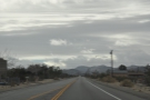 2
2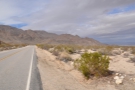 3
3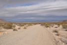 4
4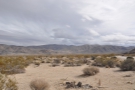 5
5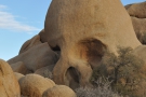 6
6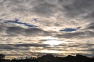 7
7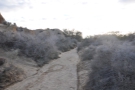 8
8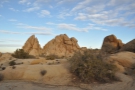 9
9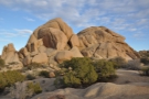 10
10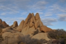 11
11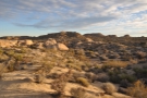 12
12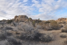 13
13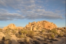 14
14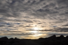 15
15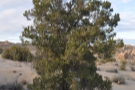 16
16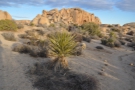 17
17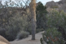 18
18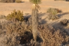 19
19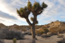 20
20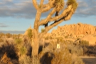 21
21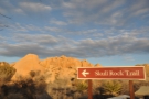 22
22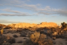 23
23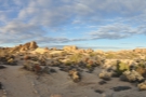 24
24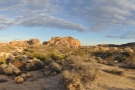 25
25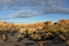 26
26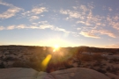 27
27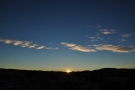 28
28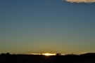 29
29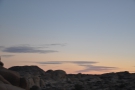 30
30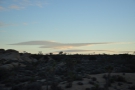 31
31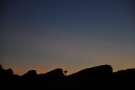 32
32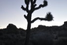 33
33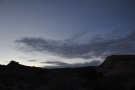 34
34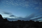 35
35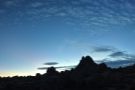 36
36One of the nice things about driving west and into California is that I got an hour back. Instead of arriving at four o’clock in the afternoon, I arrived at three o’clock. I know it makes no practical difference, but it really lifted my mood. I dropped my stuff at my hotel (another Motel 6) and headed straight back out, driving into the Joshua Tree National Park to catch the sunset.
Like most American national parks (certainly the ones I’ve been to) you need to pay an entrance fee, in this case $25 for a car, which gets you seven-day access. It might seem a lot, but I have no problem with it, since all the money goes to the upkeep of the park. The parks are also very accessible (which is partly where the money goes).
My destination that evening was Skull Rock, a 20-minute drive into the park. I could have gone further, and, with hindsight, maybe I should have done, but I was aware that night was coming and I didn’t want to spend all my time in the car. In that sense, Skull Rock seemed like a good compromise.
Even on that short drive, I went through some fairly dramatic scenery, climbing up a long valley, with mountains to my right (the same ones I could see from my motel) before turning right (west) to drive up into the foothills of the mountains themselves, which is where you find Skull Rock. In all, from the park entrance, it’s about 10 miles and a climb of around 600 m.
When I got to Skull Rock, I parked across the road and, with about 30 minutes left before sunset, I decided to walk the Skull Rock Trail, a relatively well-marked, 3 km circular trail that would bring me back to my car (which was at the eastern end of the loop) and, hopefully, give me a good view of the sunset along the way.
The trail took me through a magical landscape of desert scrub, with weird, wind-eroded rock formations (Skull Rock being the most obvious of them), plus a variety of the local flora, including my first Joshua Trees, which are members of the genus Yucca (although I believe that they are actually trees: biology is not my strong point!).
Although I really enjoyed my short ramble, the sunset itself was a little anti-climactic. In the half-hour leading up to sunset, the sky had been suitably dramatic, with lots of clouds, but these all disappeared as the sun dipped below the horizon, leaving a deep blue sky, but little else.
One thing I noticed was that it was pretty cold up there, both a function of the altitude and of the loss of direct sunlight. I was glad that I’d worn my coat and brought both my gloves and my woolly hat along! I wandered back to the car along the northern part of the Skull Rock Trail and then headed back down to Twentynine Palms.
Of course, since it had been clear at sunset, I’d hoped for clear, desert skies and a decent view of the Milky Way, but no sooner had the sun gone down than the clouds came back and I never did get a good view of the night sky!
You can find out what I got up to in my one full day in Joshua Tree National Park in the next instalment of The Grand Adventure.
If you liked this post, please let me know by clicking the “Like” button. If you have a WordPress account and you don’t mind everyone knowing that you liked this post, you can use the “Like this” button right at the bottom instead. [bawlu_buttons]
Don’t forget that you can share this post with your friends using buttons below.
Pingback: My Return to Phoenix | Brian's Coffee Spot
Pingback: Brian’s Travel Spot: Japan | Brian's Coffee Spot
Pingback: Brian’s Travel Spot: Flying To Miami | Brian's Coffee Spot
Pingback: Verve Coffee Roasters, Pacific Avenue | Brian's Coffee Spot
Pingback: Brian’s Travel Spot: Coast Starlight, Los Angeles to San Jose | Brian's Coffee Spot
Pingback: Verve Coffee Roasters, Pacific Avenue | Brian's Coffee Spot
Pingback: Brian’s Travel Spot: The Grand Adventure, Part II | Brian's Coffee Spot
Pingback: Weanie Beans | Brian's Coffee Spot
Pingback: Brian’s Travel Spot: The Grand Adventure, A Day in LA | Brian's Coffee Spot
Pingback: Intelligentsia, Venice | Brian's Coffee Spot
Pingback: Brian’s Travel Spot: The Grand Adventure, Part III | Brian's Coffee Spot
Pingback: Brian’s Travel Spot: The Grand Adventure, Hearst Castle | Brian's Coffee Spot
Pingback: Brian’s Travel Spot: The Grand Adventure, Part IV | Brian's Coffee Spot
Pingback: Brian’s Travel Spot: The Grand Adventure, Part V | Brian's Coffee Spot
Pingback: Brian’s Travel Spot: The Apache Trail, Canyon Lake | Brian's Coffee Spot