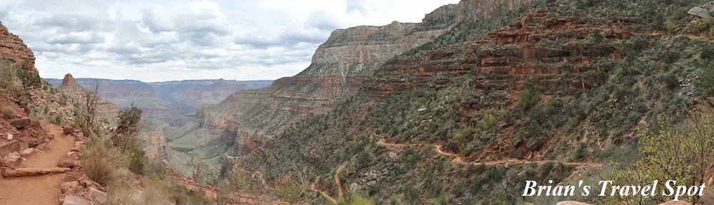
 Welcome to the third instalment of the latest Travel Spot, which takes us back to October 2016 and my first visit to the Grand Canyon, part of a wider trip which took me to Phoenix for the first time for work. With a spare weekend at the end, and knowing nothing about Phoenix (a city I’ve since come to know very well), I decided to visit to the South Rim of the Grand Canyon, somewhere I’ve always wanted to go. This post covers my day-long hike down into the Grand Canyon on the Bright Angel Trail, before I retraced my steps back to the rim.
I was staying in Tusayan, a small town just outside the southern edge the Grand Canyon National Park, having driven there from Williams on Saturday morning. That afternoon, I drove into the National Park for my first look at the Grand Canyon. To help get my bearings, and to acclimatise for my main hike on the following day, I took a leisurely 4½ hour, 13 km hike along the Rim Trail to Hermits Rest. Then, on Sunday morning, I drove back to the Grand Canyon to tackle the Bright Angel Trail.
Since this is quite a long post (it was, after all, quite a long hike), I’ve split it up as follows:
- Bright Angel Trail
- Hiking Down to Mile-and-a-Half Resthouse
- Mile-and-a-Half to Three Mile Resthouse
- Indian Garden (and beyond?)
- The Return to Three Mile Resthouse
- Back to the Top
You can see what I made of my hotel and read my thoughts about the Bright Angel Trail after the gallery.


 1
1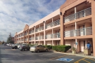 2
2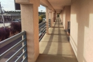 3
3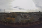 4
4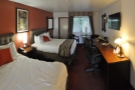 5
5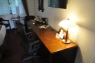 6
6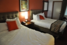 7
7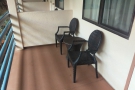 8
8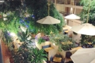 9
9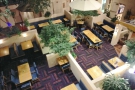 10
10 11
11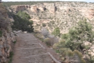 12
12Before I talk about the hike itself, a few words about Tusayan and about the Bright Angel Trail. I was staying in the Canyon Plaza Resort, one of several large hotels in Tusayan. It was effectively a bed for two nights, but as you will have seen in the gallery, my room was pretty impressive, with plenty of space and an interior balcony looking out over a courtyard restaurant. It’s certainly somewhere you could base yourself for an extended stay, although there’s not much to Tusayan itself, just hotels, a few restaurants and a couple of general stores.
I had breakfast at the hotel, then stocked up on food for the hike at one of the general stores. Although you can get provisions at the Grand Canyon Village on the South Rim (where the Bright Angel Trail starts), I figured that it would probably be cheaper and easier to get things in Tusayan. I also brought plenty of water with me. Although water is available (depending on the season) on the Bright Angel Trail, you are well advised to take enough water with you for the length of your trek and you definitely need to take plenty of food since there’s nothing available on the trail itself.
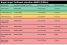
The Bright Angel Trail, which is just over 15 km (9½ miles) long, descends over 1,300 metres, all the way down to the Colorado River, where you can cross to the other side and hike up to the North Rim. It also connects with a number of other trails on the southern side of the river, giving you several options if you don’t want to retrace your steps. However, most of these will involve an overnight stay, since hiking as far as the river and back in a single day is not recommended, while hiking all the way to the North Rim is definitely a two-day affair. It’s also worth noting that, other than camping, there is no accommodation inside the Grand Canyon itself (and I had no camping gear with me). With all that in mind, I limited myself to a day-hike with the aim of getting as far down the Bright Angel Trail as I could before turning around and retracing my steps back to the rim.
The good news is that Bright Angel has several convenient turnaround points, including the Mile-and-a-Half and Three-Mile Resthouses (1½ and 3 miles into the canyon respectively) and Indian Garden (about 7 km or 4½ miles), where you’ll find a campground. From here, Bright Angel continues down to the Colorado River, while a side trail leads to Plateau Point, which overlooks the river. My aim was to get at least as far as Indian Garden and, if I had time, to make the round trip to Plateau Point (5 km/3 miles there and back) before returning to the South Rim.
You can find out whether I made it in the rest of the post, starting with my initial descent from the rim, which you can read about after the gallery.


.")


.")


 flat for a bit before...")


.")


.")


 1
1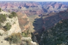 2
2 3
3 4
4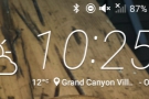 5
5 6
6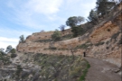 7
7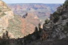 8
8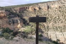 9
9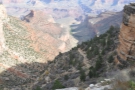 10
10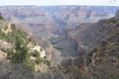 11
11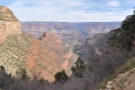 12
12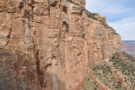 13
13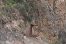 14
14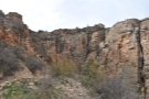 15
15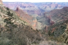 16
16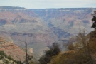 17
17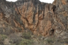 18
18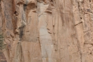 19
19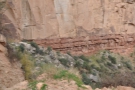 20
20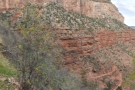 21
21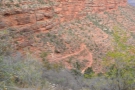 22
22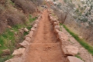 23
23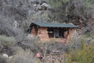 24
24 25
25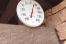 26
26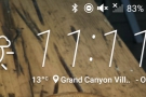 27
27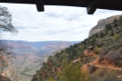 28
28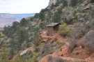 29
29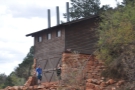 30
30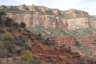 31
31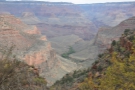 32
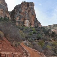
32The early stages of the Bright Angel Trail are well-maintained, a broad path descending (relatively) slowly via a pair of long switchbacks which cut along the near vertical rock walls at the top of the valley. After about 15 minutes of walking, you are almost back where you started, directly beneath the Kolb Studio, albeit about 100 metres lower!
The trail continues via a short tunnel cut through the rock, after which the switchbacks start to get a lot tighter and steeper, the trail descending rapidly between two sheer walls of rock, the switchbacks expanding like a fan as you descend. At the bottom of the switchbacks, the trail flattens out again and it’s a relatively straight and (comparatively) flat ½ km hike to the Mile-and-a-Half Resthouse. This suddenly appears a little way above the trail on the right, accessed via a short side trail that loops up and back on itself.
There’s no obligation to stop, but by this point I’d been going for around 45 minutes, having covered 1½ km and descended 340 metres, so I thought it was time for a break. There’s not much to the Mile-and-a-Half Resthouse, just four stone walls with a roof, an opening for a door and three more for windows. There’s also a thermometer mounted above the door which read 53°F (12°C), the same temperature that my phone had registered at the start of the hike.
One of the interesting things about hiking into the Grand Canyon is that you start by hiking down. Pretty much all the hiking I’d done up until that point was either along things (coastline, rivers, etc) or up things (hills or mountains). Hiking up mountains means you do the hardest part (in terms of physical exertion) when you are at your freshest, with the return down the mountain at the end of then day when you were tired.
In contrast, doing a day-hike into the canyon means that you start with a significant descent, then, when you are tired, end the hike with an equally significant climb. I think I’m in a minority of hikers who prefers it this way around. While going up requires more effort, I find going down much harder on my joints and I’d much rather do that when I’m fresh than at the end of the day when I’m tired and more likely to make a mistake. It also means that by the time I’m coming back up, my pack is a little bit lighter, since I’ve eaten most of my food and drunk my water!
Something I’ve learnt from many years of hiking is to pace myself, so I took a decent break at the Mile-and-a-Half Resthouse, staying for around 25 minutes. This was enough time to catch my breath and have a bite to eat (another lesson I’ve learnt while hiking: eat small amounts frequently rather than have one or two larger meals).
My final act before carrying on down the Bright Angel Trail was to visit the toilet block. This is a separate (and more substantial) building off the trail to the right. This, by the way, is not for a faint-hearted. It’s a pit toilet, with three separate cubicles, each no more than a seat above a hole in the floor which opens over a massive pit some considerable distance below. The smell, shall we say, is rather strong!
With that out of the way, I carried on, heading for my next stop, the Three Mile Resthouse. You can see how that went after the gallery.
.")


, Plateau Point.")

 side of the valley before returning...")


 side of the valley was formed by this amazing...")


 with its toilet block beyond it to the right.")


, significantly warmer than it was at the top!")


 1
1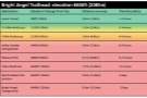 2
2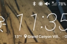 3
3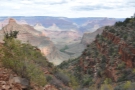 4
4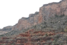 5
5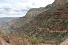 6
6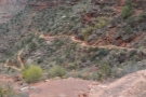 7
7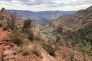 8
8 9
9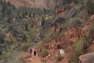 10
10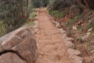 11
11 12
12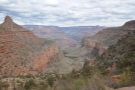 13
13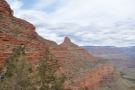 14
14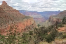 15
15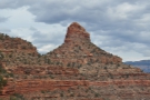 16
16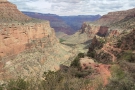 17
17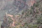 18
18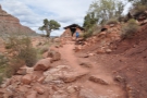 19
19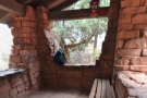 20
20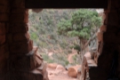 21
21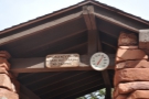 22
22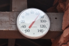 23
23 24
24 25
25 26
26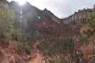 27
27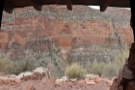 28
28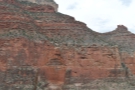 29
29 30
30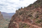 31
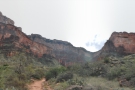
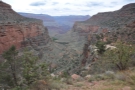
31From the Mile-and-a-Half Resthouse the Bright Angel Trail carries on for another 2.4 km (1½ miles) to the Three Mile Resthouse, descending a further 305 m along the way. Unlike the first section of the trail, where the bulk of that descent is in the initial stages, here the descent is steadier. At this point, I was still near the top of the side valley, which the Bright Angel Trail follows from the rim all the way down to Indian Garden.
The Mile-and-a-Half Resthouse is at the top of a narrow ridge on the eastern side of the valley. The direct route down is to follow the top of the ridge as it descends, but to make things easier for the likes of me, the trail takes a series of switchbacks of ever-decreasing size, the first of which is quite shallow, taking in a large loop which crosses a dry stream bed to on the other side of the valley before returning to the eastern flank.
From here, as the valley broadens and the bottom drops away, the trail clings to the side of the ridge on the valley’s eastern flank, descending via the ever-decreasing switchbacks. Crossing another dry stream bed, the trail clings to the flanks of a second ridge as it too drops towards the valley floor, ending in a promontory which houses the Three Mile Resthouse.
I left the Mile-and-a-Half Resthouse at 11:35, arriving at Three Mile Resthouse just under 45 minutes later, a near identical pace compared to my first 2.4 km. One of the counter-intuitive (but obvious when you think about it) things about hiking down into the Grand Canyon is that it gets warmer as you descend. I’m used to hiking up mountains, where it gets colder the further you go, so I have to put on additional layers the higher I get.
Here I was starting at the top (at an elevation of over 2,000 m), where it was a wonderfully cool 12°C, an ideal hiking temperature. There hadn’t been any drop in temperature on my way down to the Mile-and-a-Half Resthouse, but it was still relatively early and that part of the valley was in shade for much of the morning. In contrast, by the time I arrived at the Three Mile Resthouse, which had been in the sun for a while, it was already up to 19°C, my floppy sunhat had come out and I had started shedding layers.
Like the Mile-and-a-Half Resthouse, there’s not much to the Three Mile Resthouse. It’s right at the tip of the promontory, overlooking the valley below, and is set slightly above the main trail and accessed via its own path, with another pit toilet block beyond that (which I decided not to visit). The construction is also similar, with four rough, stone walls, a tiled roof and openings for a door and three windows. The main difference is, unlike the Mile-and-a-Half Resthouse, which very much sneaks up on you (on the way down), the Three Mile Resthouse is visible from a long way off (if you know what you are looking for, you can see it well before you reach the Mile-and-a-Half Resthouse).
In all, I stayed for 20 minutes, catching my breath, having something to eat and enjoying the views. Then it was time to carry on, down to the valley bottom and Indian Garden.


 the geology. What are those white sections?")


.")


 1
1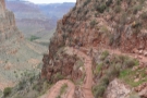 2
2 3
3 4
4 5
5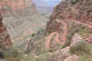 6
6 7
7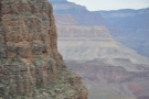 8
8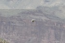 9
9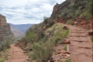 10
10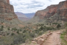 11
11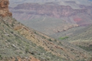 12
12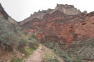 13
13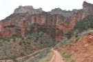 14
14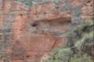 15
15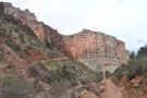 16
16 17
17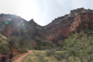 18
18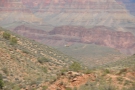 19
19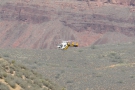 20
20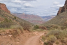 21
21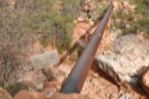 22
22 23
23 24
24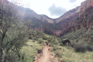 25
25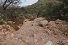 26
26 27
27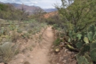 28
28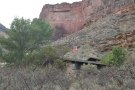 29
29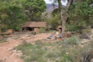 30
30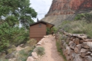 31
31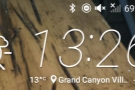 32
32 33
33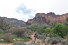 34
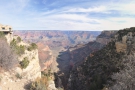
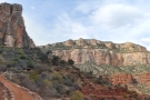
34From Three Mile Resthouse, it’s another 2.4 km (1½ miles) to Indian Garden, descending 280 m, slightly less than the previous two sections. As it did at the start of the Bright Angel Trail, the bulk of this descent comes at the beginning of the section, with the trail quickly dropping down the western flank of the promontory via a series of switchbacks, from where I caught my first glimpse of the Grand Canyon National Park Service helicopter, which was buzzing around over Plateau Point.
Once the trail reaches the valley floor, the descent is much gentler, although there is one more extended switchback, the trail doubling back on itself as it goes round the final part of the ridge that Three Mile Resthouse sits on. From there to Indian Garden was the easiest section of the trail so far and soon I reached a large information sign.
This marks the southern boundary of Indian Garden, which extends for about 400 m along the Garden Creek. Although the creek bed was dry, given how green the area was, there was obviously water not far below the surface. Compared to the rudimentary nature of the Mile-and-a-Half and Three Mile Resthouses, Indian Garden is a metropolis, with a ranger station, a large campground, several shelters and another toilet block.
I stopped at the campground, having completed the third 2.4 km section of my hike in 45 minutes, which capped a remarkably consistent pace. I had something to eat and drink and then assessed my options.
From Indian Garden, the Bright Angel Trail carries on north, following the Garden Creek as it drops steeply down to the Colorado River at the bottom of the Grand Canyon. I’d already ruled that out, since it was a two-day hike if I wanted to get to the river and back, and I didn’t see the point of just going a short way down before turning around.
The Tonto Trail, running east to west, crosses the Bright Angel Trail just north of Indian Garden. The trail is over 150 km long and is entirely within the canyon, never reaching the rim at any point. From here, I could follow it west, where it connects with the Hermit Trail, or east, where it connects with the South Kaibab Trail. However, going in either direction involves a two-day hike, so, like a descent to river, that had already been ruled out.
That just left a simple choice: carry on north along the Plateau Point Trail for some views over the river before returning to Indian Garden, or turn back now and leave Plateau Point for another time.
It was now 13:50 and it had taken me 2¼ hours to hike down to Indian Garden, plus another 45 minutes resting along the way, making a total of three hours. The standard (cautious) advice when hiking the Grand Canyon is to allow twice as long to get back up as it took you to get down, which would suggest six hours for my return. However, over many years of hiking, I’ve learnt that I descend slower than average and go up comparatively faster, so I was budgeting for the hike back to take 50% longer, or 4½ hours.
That would get me back to the trailhead at 18:20, or, to put it another way, about twenty minutes after sunset. This wasn’t ideal, but having been on the Rim Trail at dusk the day before, I knew that there would be more than enough light for me to complete the final part of the hike. And, having come down that way, I knew that the conditions under foot would be fine.
However, it meant that a hike out to Plateau Point and back was out of the question. I really wanted to do it, but I was going to have to save it for another day. So, with some reluctance (and acknowledging that I really do need to get up earlier!), I put my pack back on, turned around and started the long trek back to the trailhead.
You can find out how I got on with my hike back to the South Rim after the gallery.
 lowest point on the rim.")


 flat section south of Indian Garden...")


.")


 1
1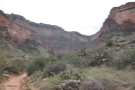 2
2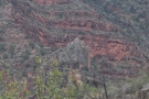 3
3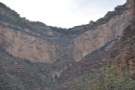 4
4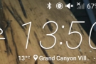 5
5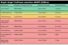 6
6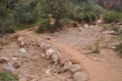 7
7 8
8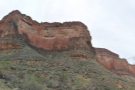 9
9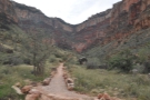 10
10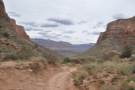 11
11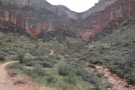 12
12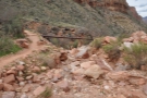 13
13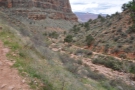 14
14 15
15 16
16 17
17 18
18 19
19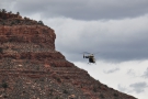 20
20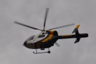 21
21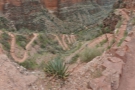 22
22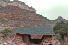 23
23 24
24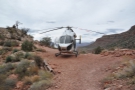 25
25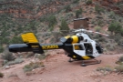 26
26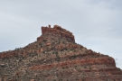 27
27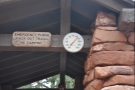 28
28 29
29 30
30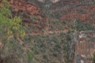 31
31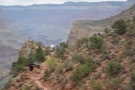 32
32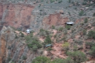 33
33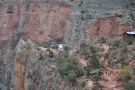 34
34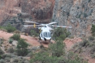 35
35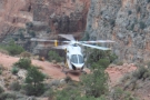 36
36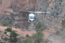 37
37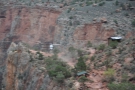 38
38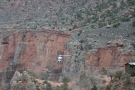 39
39 40
40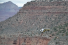 41
41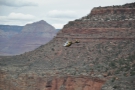 42
42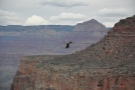 43
43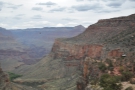 44
44I left Indian Garden at 13:50 to start my hike back to the rim. The return leg begins gently enough, slowly ascending the valley as the trail runs parallel to the dry stream bed of Garden Creek. However, once you reach the promontory beneath the Three Mile Resthouse, it rapidly becomes a slog, the path climbing steeply via the numerous switchbacks. It took me 25 minutes from leaving Indian Garden to the first of the switchbacks and a further 35 minutes to make it back to the top. In contrast, earlier in the day I’d made it down the switchbacks in just 20 minutes, taking an identical 25 minutes to get from the bottom to Indian Garden.
On my way up, I heard the Grand Canyon National Park Service helicopter again. This time it was a lot closer, flying almost directly overhead before disappearing from both sight and hearing. Since I hadn’t seen it fly back out of the valley, I could only assume that it had landed somewhere, although looking at the surrounding terrain, I really wasn’t sure where that could be!
I discovered the answer to my conundrum when I got to the Three Mile Resthouse at the top of the switchbacks. This is built on the tip of the promontory, beyond which is the toilet block while, right at the tip, there’s a rare flat piece of ground. This is where the helicopter had landed, with the pilot sitting a little way off on some rocks.
I had intended to take my break in the resthouse, but it soon became apparent that this wasn’t going to happen. A hiker, on his way up from Indian Garden, had got into difficulties, experiencing shortness breath, so his daughter, who was hiking with him, had called for help on the emergency telephone in the resthouse. The hiker was now in the resthouse, being attended to by a paramedic, who was the helicopter’s other crew member.
Having nowhere else to go, but still needing a rest, I went to chat with the pilot, who confirmed my suspicions that he did indeed have the best job in the world, getting to fly around the Grand Canyon every day. He also told me how few landing spots there were this high up in the canyon, which, given the terrain, wasn’t surprising.
Chatting with the pilot, I found out what would happen next. Assuming the hiker couldn’t continue, he’d be airlifted to the Grand Canyon Village, a service provided free of charge by the park service. However, there was a sting in the tail: anyone airlifted out is met by an ambulance which takes the casualty to a hospital in Flagstaff and that leg of the journey is charged at normal (eyewatering) US rates. Having been in an ambulance in the US and seen the bills that were sent to my insurers, I can confirm that this isn’t something you want to have to pay for out of your own pocket!
I’d been there for about 15 minutes when the paramedic returned, confirming that the hiker would indeed need medical evacuation, so I took this as my cue to get out of the way while the pilot started preparing for take-off. The final indignity in all this is that while the hiker got airlifted out, there was no room for his daughter, so she had to continue her hike out, then make her own way to the hospital in Flagstaff at the end of it all.
I set off for the next stage of my journey at 15:10, getting a short way up the trail before turning around to watch the helicopter depart. Then it was back to the hike.
You can see how the rest of my hike, all the way to the trailhead, went after the gallery.

 which I've just left, and, down in...")


 easy going at first, but then the switchbacks start.")


, only slightly warmer than on the way down.")


 win.")


, I'll leave you here.")
 1
1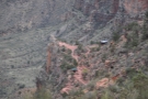 2
2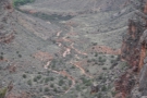 3
3 4
4 5
5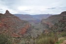 6
6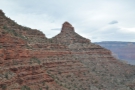 7
7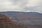 8
8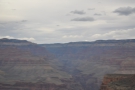 9
9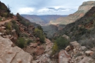 10
10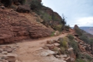 11
11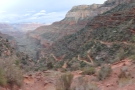 12
12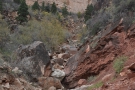 13
13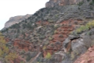 14
14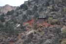 15
15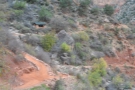 16
16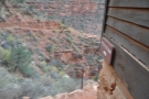 17
17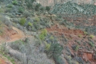 18
18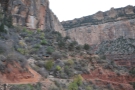 19
19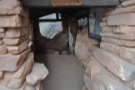 20
20 21
21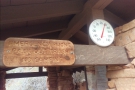 22
22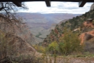 23
23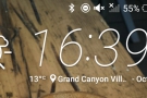 24
24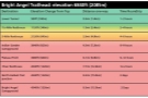 25
25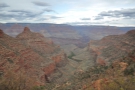 26
26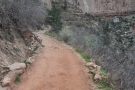 27
27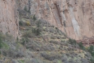 28
28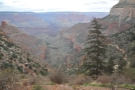 29
29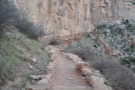 30
30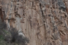 31
31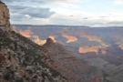 32
32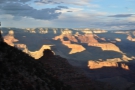 33
33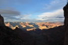 34
34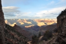 35
35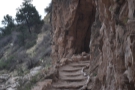 36
36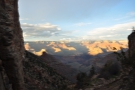 37
37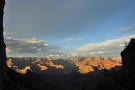 38
38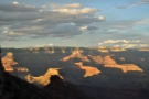 39
39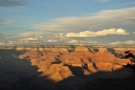 40
40 41
41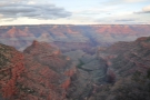 42
42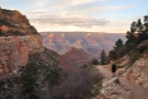 43
43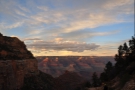 44
44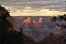 45
45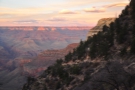 46
46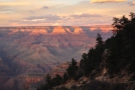 47
47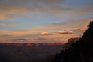 48
48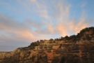 49
49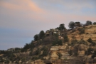 50
50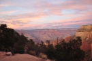 51
51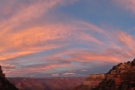 52
52 53
53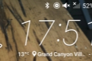 54
54 55
55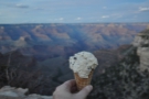 56
56Mercifully, after the climb up to Three Mile Resthouse, the trail starts off comparatively gently as it makes its way back up the canyon towards the Mile-and-a-Half Resthouse. Unlike on the way down, when the resthouse suddenly appears above the trail, on the way up, its much more visible, perched on the narrow ridge below the sheer rock faces just below the canyon’s rim.
After the relatively gentle start, things get harder as the trail reaches the next set of switchbacks, marking in the climb up to the Mile-and-a-Half Resthouse, where I took another break. By this time, I was starting to feel the strain: it had taken me 45 minutes to get between the two resthouses on the way down. On the way back up, it took me an hour and 10 minutes. This was 10 minutes more than I’d take between Indian Garden and Three Mile Resthouse, although that first leg had only involved 280 metres of ascent, while getting to the Mile-and-a-Half Resthouse meant climbing 305 metres.
On that basis, my rate of climb was fairly consistent, which is what I would expect and, overall, I was making good time. I’d reached the Mile-and-a-Half Resthouse at 16:20 and, after resting for 20 minutes, I set off again, with just the final 340 metres of ascent to go. More importantly, I had an hour and 20 minutes before dusk, so I was confident I would make it.
Of course, the trail saves the hardest part for last as, once again, there’s a relatively easy section immediately after the Mile-and-a-Half Resthouse, followed by the fairly brutal switchbacks which climb between the two sheer faces of rock to where the trail tunnels through the rock itself. From there the worst was behind me, although I still had more than 100 metres of ascent to go.
I didn’t help myself by continually stopping to look back, partly to admire the views and pick out landmarks where I’d been, but also to take in the increasingly stunning sunset. This progressively illuminated the north side of the Grand Canyon, bringing out some amazing colours. As good as the sunset had been the day before, this was so much better.
I eventually reached the trailhead ahead of schedule at 17:50, completing the final leg in an hour and 10 minutes and the whole ascent in just four hours (compared to three hours going down). I was pleased to have got back before dusk, but perhaps more importantly, I’d made it before the ice cream parlour closed at six o’clock. I rewarded myself with an ice cream before heading back to my car for the drive back to my hotel and some well-earned rest.
This concludes my hike down the Bright Angel Trail and back. You can read about the rest of the trip in the final instalment of this Travel Spot, which covers my last morning at the Grand Canyon, my drive back to Phoenix and my flight home that evening.
Don’t forget that you can share this post with your friends using buttons below, while if you have a WordPress account, you can use the “Like this” button to let me know if you liked the post.