 Welcome to the final instalment of the latest Travel Spot, looking back to October 2016 and my first visit to the Grand Canyon. I’d started exactly a week before, arriving in Phoenix for the first time for work. Then, at the weekend I drove up to the South Rim of the Grand Canyon, acclimatising myself with a half-day hike along the Rim Trail to Hermits Rest before spending Sunday on a day-long down-and-back hike into the Grand Canyon on the Bright Angel Trail.
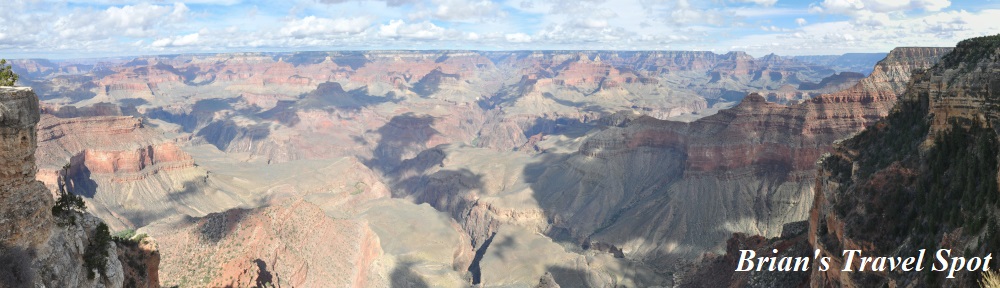
On Monday morning, it was time to end my all-too-brief visit to the Grand Canyon. After breakfast at the South Rim, I took an hour and a half’s stroll along the Rim Trail, this time heading east to Yavapai Point, following the Trail of Time. Then it was back to my car for the return drive to Phoenix. Rather than retrace my route, I drove east out of the National Park along Desert View Drive, stopping on multiple occasions to admire the view. From there, I carried on east to Cameron, picking up Route 89 for long drive south to the airport, where I caught my flight back to the UK that evening.
You can find out how I got on after the gallery.


 is on the far left, while Yavapai Point is on the right. Directly ahead is Maricopa Point, which is on the Rim Trail going west from the Grand Canyon Village.")


 with Mary Colter's Lookout Studio (right).")


.")

 1
1 2
2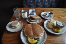 3
3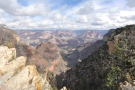 4
4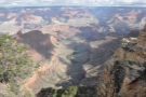 5
5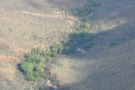 6
6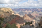 7
7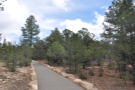 8
8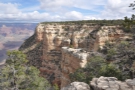 9
9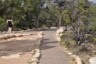 10
10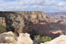 11
11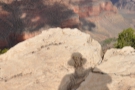 12
12 13
13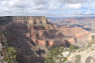 14
14 15
15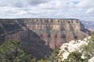 16
16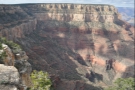 17
17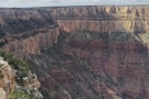 18
18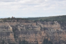 19
19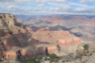 20
20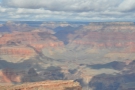 21
21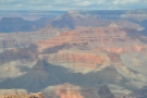 22
22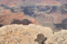 23
23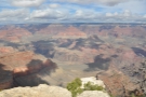 24
24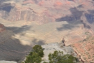 25
25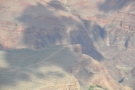 26
26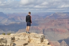 27
27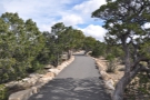 28
28 29
29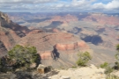 30
30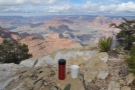 31
31 32
32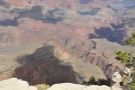 33
33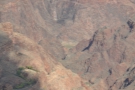 34
34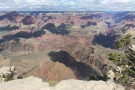 35
35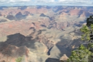 36
36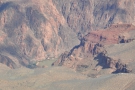 37
37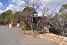 38
38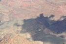 39
39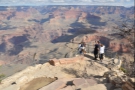 40
40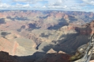 41
41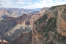 42
42 43
43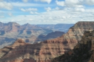 44
44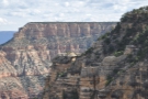 45
45I was up relatively early (for me) and, rather than have breakfast at the hotel (which was fine, by the way, I just wanted a change), I checked out and drove into the Grand Canyon National Park one last time, parking in roughly the same spot close to the Grand Canyon Village. By ten o’clock I was at the Bright Angel Lodge, settled into a booth with a window looking out over the Grand Canyon, having eggs, pancakes, hash browns, toast and an English muffin for breakfast.
Suitably fortified, I took my last walk along the rim, this time following the Rim Trail east to Yavapai Point. This section of the Rim Trail is fully paved and is part of the Trail of Time, which starts at the Yavapai Geology Museum and runs through the Grand Canyon Village, carrying on as far as Maricopa Point on the western part of the Rim Trail (which I hiked on Saturday afternoon, shortly after arriving at the Grand Canyon). Each metre walked along the trail marks one million years in the Grand Canyon’s geological history, with plenty of interpretative boards, plus rock samples recovered from the canyon, placed at strategic points along the way.
If you start at the Yavapai Geology Museum and walk west to the village, you are effectively walking back in time, whereas I walked east from the village, starting in the Grand Canyon’s deep geological past, around two billion years ago and moving forward in time. When I say the Grand Canyon’s geological past, this is a little deceptive since the canyon itself is a mere five to six million years old. Instead, the Trail of Time is referring to the ages of the rocks which make up the different layers of the canyon, with the oldest rocks (around 1.8 billion years old) at the bottom of the Grand Canyon. In contrast, the rocks at the South Rim are a mere 270 million years old.
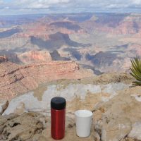
Yavapai Point is a little way past the geology museum, so in all I covered around 3 km, which took me about an hour and a half. This was largely because I kept stopping to read the information boards and to admire the views, starting with the Bright Angel Trail which I’d hiked the day before, and ending with a look across at the South Kaibab Trail (not that I knew it at the time, but I would hike the South Kaibab Trail on my return to the Grand Canyon in January 2020). I also stopped for coffee (which I’d made that morning in my hotel room), taking some photos of my Travel Press and Therma Cup standing on the rim, inadvertently setting in motion events which would lead to my Travels with my Coffee series.
From Yavapai Point, I caught the shuttle bus back to the village, picked up my car and began my long drive back to Phoenix, ready for my flight home that evening.
See how the first part of my drive went after the gallery.


.")


 1
1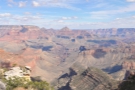 2
2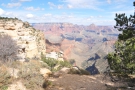 3
3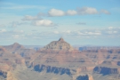 4
4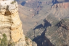 5
5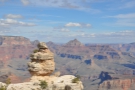 6
6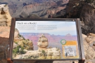 7
7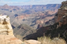 8
8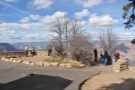 9
9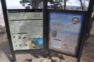 10
10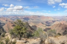 11
11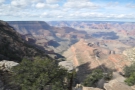 12
12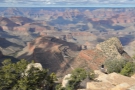 13
13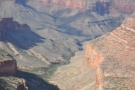 14
14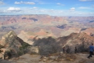 15
15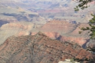 16
16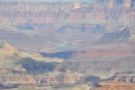 17
17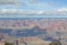 18
18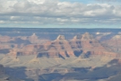 19
19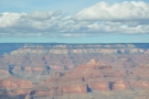 20
20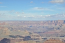 21
21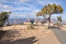 22
22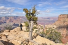 23
23 24
24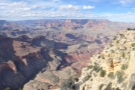 25
25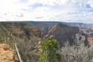 26
26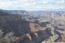 27
27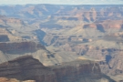 28
28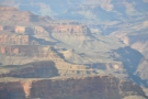 29
29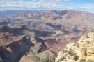 30
30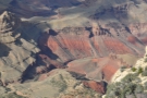 31
31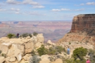 32
32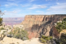 33
33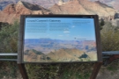 34
34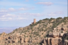 35
35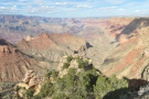 36
36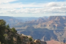 37
37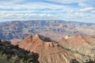 38
38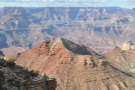 39
39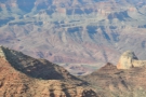 40
40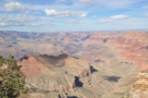 41
41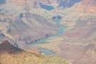 42
42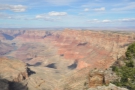 43
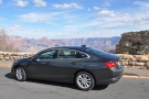
43I got back to my car at around 12:45, ready for my return to Phoenix. However, my flight home wasn’t until nine o’clock that evening and, even accounting for the extra time required to return the hire car, I still had a leisurely journey ahead of me.
The most direct route from the Grand Canyon Village was to retrace my steps from the drive up on Friday/Saturday, heading south on Route 64 before picking up I-40 to Flagstaff, where I’d drive back down I-17 to Phoenix. This would take 3½ hours, but since I didn’t need to drop the hire car off until around 18:30, I decided to take the indirect route.
This involved driving east along Route 64 to the Desert View Watchtower and the eastern entrance to the Grand Canyon National Park. From there, Route 64 continues east to Cameron, where Route 89 would take me south to Flagstaff and I-17. Coincidentally, the drive from the Desert View Watchtower to Phoenix is also 3½ hours, so I figured that as long as I left the watchtower by three o’clock, I’d be fine.
This gave me just over two hours to cover the 40 km from the village to the watchtower, where Route 64 goes by the name Desert View Drive, often hugging the South Rim of the Grand Canyon, with plenty of pull offs along the way, which, naturally, I planned to make the most of.
My first stop was about 10 km east of the village at the delightfully named Duck on a Rock Viewpoint (named for a rather precariously balanced rock formation), where I spent a few minutes admiring the view. From then on, my journey a familiar pattern: drive for about 15 minutes/10 km, then pull over to admire some more views, stopping at Grandview Point, Moran Point and Navajo Point, my final stop before the Desert View Watchtower, where I arrived just before 14:30.
It was a wonderful drive, which I’d highly recommend, particularly if you are coming into the national park from the east, where it gives a great introduction to the Grand Canyon. Although I loved the views from the Grand Canyon Village and the Rim Trail, you get a very different perspective the further east you go, seeing much more of the Grand Canyon and the Colorado River, which is clearly visible from Navajo Point, a short drive from the Desert View Watchtower.
Sadly, you really do need a car since there doesn’t seem to be a public transit option. While the Grand Canyon Village and the Rim Trail are well-served by the free shuttle buses, these don’t extend any further east than Yaki Point and the South Kaibab Trailhead, just over 5 km east of the village.
The good news is that I still had time to look around the Desert View Watchtower before I had to head off to Phoenix.
You can see what I made of it after the gallery.


...")
.")


, all the way to the view down the Grand Canyon to the west (left).")


 1
1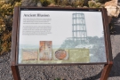 2
2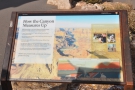 3
3 4
4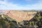 5
5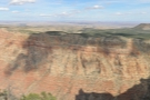 6
6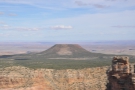 7
7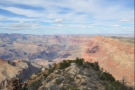 8
8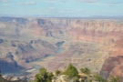 9
9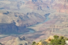 10
10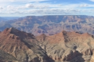 11
11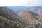 12
12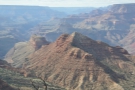 13
13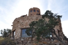 14
14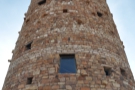 15
15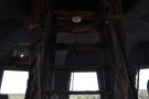 16
16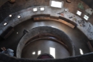 17
17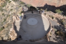 18
18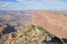 19
19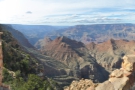 20
20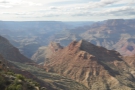 21
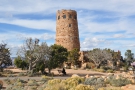
21The Desert View Watchtower is a deceptive structure. Designed by Mary Colter, it was built in 1932, but looks much older, its concrete and reinforced steel skeleton covered by an outer skin of weathered local stone. The effect is striking, and the 21-metre-high tower dominates the area, standing just northeast of the eastern entrance to the Grand Canyon National Park. As well as the tower, there are a couple of stores, a large carpark, picnic areas, toilets and even a petrol station. If you are coming into the park from the east, it’s a good place to stock up on provisions.
The tower itself has a gift shop on the ground floor, above which the tower is a circular shaft, with two interior circular balconies linked by narrow staircases. Finally, there’s an enclosed viewing platform at the top. There’s also a larger viewing platform on the north side of the tower, which itself stands at the top of a narrow ridge running north down into the Grand Canyon, affording some spectacular views from the third platform at the tip of the ridge.
Looking north, you can clearly see the Colorado River as it flows south, the kilometre-high cliffs of the Marble Platform forming its eastern boundary. As it approaches the watchtower, the Colorado turns abruptly west, a course it then broadly follows (with plenty of turns) all the way to the Hoover Dam at the Grand Canyon’s eastern end. Whether you are entering the park from the east, or, like me, leaving it, Desert View Watchtower is worth a stop just for these views.
With time marching on, I took my leave of the watchtower and the national park and, at 14:45, set off east along Route 64. My first target was Cameron, a small town on the Little Colorado River which flows west and north from there to join the Grand Canyon, although technically I was aiming for the junction with Route 89, which is a little way south of Cameron.
While not as spectacular as the Grand Canyon, the drive down to Route 89 was pretty impressive, passing through a variety of landscapes. This includes sweeping hills to the south and west and a fairly swift descent to the Little Colorado River Gorge, itself an impressively steep-sided affair. There is an overlook where you can pull off the road for a closer look, but sadly I didn’t have time to stop.
After the overview, the landscape broadens and flattens out, Route 64 swiftly joining up with Route 89 which runs north from Flagstaff. If you were heading for the North Rim of the Grand Canyon, which is another 2¾ hours’ drive away, you’d turn left here. I, of course, was heading in the opposite direction, turning south for my drive to Flagstaff, where I picked up I-40, skipping the town altogether.
While I had vivid memories of the landscape east of the Grand Canyon, I don’t really remember much of the drive south, although the road does pass east of the San Francisco Mountains as it approaches Flagstaff. Again, I don’t recall that much of the scenery, although I do remember being impressed when I returned to the area at the start of 2018, spending a few days in and around Flagstaff which gave me time to explore.
I wasn’t on I-40 for long before turning onto I-17 for the two-hour drive south to Phoenix. This simply reinforced my impression from the drive up as I retraced my steps through some stunning scenery, this time dropping 1,500 metres from the plateau. I made it to the Rental Car Center in plenty of time, dropped off my car and caught the shuttle bus to the airport.
You can see what I got up to at the airport, and how my flight home went, after the gallery.


 1
1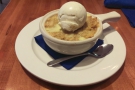 2
2 3
3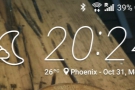 4
4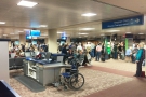 5
5 6
6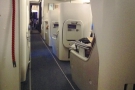 7
7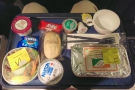 8
8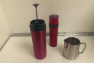 9
9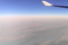 10
10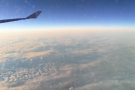 11
11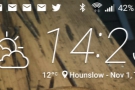 12
12I’d allowed myself plenty of time to get to the airport, worried that I might run into evening traffic. As it was, everything went smoothly, I-17 taking me to within a couple of blocks of the car rental center. Even allowing time to fill up the car at a nearby petrol station before dropping it off, I reached the airport in plenty of time.
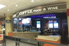
I checked in for my flight and got through security quickly enough, which left me with a couple of hours to kill. In an ideal world, I would have got coffee, but although both Press Coffee and Cartel Coffee Lab had coffee bars in the terminal building, and despite my early arrival, they were closed by the time I arrived. The good news is that Cartel Coffee Lab now opens much later in the evening (and I’ve visited many times since). The bad news is that Press Coffee has since closed its airport coffee bar.
Instead, I went looking for a mailbox. I had several postcards which I’d written that morning, including one I’d finished at the car rental center while waiting for the shuttle bus, and they all needed posting. I’d asked about it when I checked in, and was assured that there was a mailbox airside (that is, past security), but now that I was there, I couldn’t find one, or find anyone who knew where one was.
Eventually, someone remembered seeing a mailbox at the American Airlines helpdesk, but when I got there, I found out it was just for show. However, the helpful staff informed me that, contrary to what I’d been told at check-in, there was no mailbox airside. In fact, there was just a single mailbox for the whole of the main terminal, which was located on the kerb outside departures!
My only option was to leave the terminal building, post my cards, then come back through security which, I was assured, would be fine. After a little bit of deliberation (mostly to do with a nagging worry that going through security twice would cause problems) I decided to go for it. After all, I still had plenty of time, so if things went wrong, I wouldn’t be in a hurry, plus I had a bunch of postcards with US stamps attached that really needed posting.
So off I went. I wandered out of the airside part of the terminal, past the intimidating “no return beyond this point” signs and then went outside. I found the mailbox exactly where the American Airline staff had said it was (ironically, it’s right where the shuttle buses from the car rental center drop you off, something which has held me in good stead ever since), posted my cards, then headed back to security. I’ll confess I was a little apprehensive and I’m not sure this would work at an airport like Heathrow (where they take your photo when you enter security), but at Phoenix, I was allowed through security a second time without anyone batting an eyelid.
Back in the departures area and despite the queues at security (which were inevitably longer the second time around), I still had about an hour to kill. I treated myself to an apple cobbler from the one restaurant that was still open, then made my way down to the gate, where people were queuing ahead of boarding the flight.
I honestly remember even less about the flight back than I did about the flight over, which lacked even the drama of having someone arrested. We boarded in good order and I easily found my seat, which was the same bulkhead aisle seat I’d had on the way out. I settled in and, after dinner, when everyone else was trying to get some sleep, I worked away on my laptop, getting up for regular walks and, on one occasion, to make coffee with my Travel Press.
This helped me through the night, which passed surprisingly quickly (it helps that it’s always quicker flying east to west across the Atlantic). Before I knew it, I was back in a decidedly autumnal UK, although to be fair, the temperature perfectly matched the South Rim of the Grand Canyon where I’d been less than 24 hours before. Tired, but happy, I made my way home and to my bed.
This concludes my Travel Spot, Phoenix and the Grand Canyon, from October 2016. I hope you enjoyed it. Check out the Travel Spot Page for more of my travel adventures.
Don’t forget that you can share this post with your friends using buttons below, while if you have a WordPress account, you can use the “Like this” button to let me know if you liked the post.