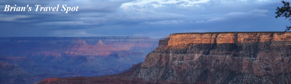
 Welcome to the second instalment of the latest Travel Spot, which takes us back to 2016 and my first trip to Phoenix. It’s somewhere I’ve since come to know very well but back then, knowing nothing about the city and being short on time, I gave it a miss. Instead, I used my spare weekend for another first: a visit to the Grand Canyon. Or, to be more precise, a visit to the South Rim of the Grand Canyon National Park, which is easily accessible from Phoenix. The North Rim, in contrast, is another three hours’ drive, since you have to get around and over the canyon! Alternatively, you can hike between the two, given a couple of days!
The first instalment of this Travel Spot covered my flight out, my first impressions of Phoenix and the drive to the Grand Canyon, where I arrived on Saturday morning, having split my journey overnight at the town of Williams. The Grand Canyon is somewhere I’d always wanted to visit and, as you will see, even though I only had 48 hours there, I was not disappointed, either with the canyon itself or with the two hikes I managed to get in.
You can read about my first impressions after the gallery.

 shuttle bus, but from there I could walk...")


 a little, you can see the side valley that the village is at...")
.")


 1
1 2
2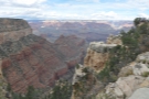 3
3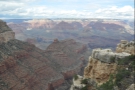 4
4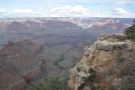 5
5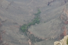 6
6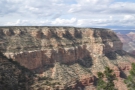 7
7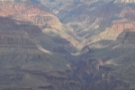 8
8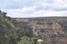 9
9 10
10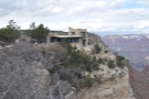 11
11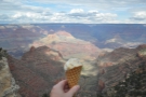 12
12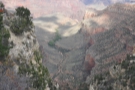 13
13 14
14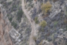 15
15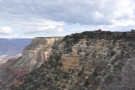 16
16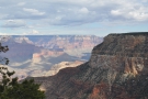 17
17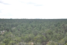 18
18I was staying in Tusayan, a small town just outside the southern edge the Grand Canyon National Park. It is possible to stay within the National Park, on the South Rim itself, but accommodation books up months in advance, so Tusayan was the next best thing. After driving up from Williams, I stopped briefly to check into my hotel, drop my bags and get my bearings. There’s a Grand Canyon visitor centre in the town, where I bought my pass (you need one to get into the National Park, which is good for seven days; now you can get them online too).
Although there is a shuttle bus which runs from Tusayan to the canyon, I decided to make the 10-minute drive, since that gave me extra flexibility. The entrance to the park (where you have to show your pass) is a couple of minutes north of Tusayan and the rest of the drive is fairly unspectacular, passing over a high plateau covered by pine forest. You can’t drive directly to the rim of the canyon: instead, leave your car in one of the many well signposted car parks, which are linked to each other and the rim by walking trails and free shuttle buses.
One option is to start at the Visitor Centre, which is to the east, by Mather Point. However, I went for the Grand Canyon Village to the west. This collection of buildings strung out along the rim is where the Grand Canyon Railway brings you in. It’s also home to several of the lodges, should you find yourself staying in the park, plus some shops, restaurants and other amenities. Parking is limited in the village and it was busy, but I was able to find somewhere just south of the railway station, from where I made the short walk to the rim.
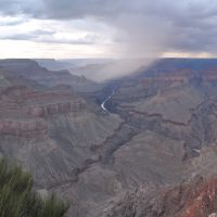
At first, I wondered what all the fuss was about. The approach to the rim is rather flat, so initially you don’t really see anything as you look out across the top of the canyon to the far side. And then, suddenly, it’s there, this massive gash in the earth, stretching away to the left and right, with the far side of the canyon a long, long way off in the distance (at this point, the canyon is roughly 12 km wide).
You can read about the canyon as much as you like, and look at all the photos in the world, but nothing really prepares you for how big it actually is. However, as much as the sheer scale of the canyon took my breath away, what impressed me more were the colours. I hadn’t expected it to be so colourful. The pictures in the gallery don’t really do it justice: standing there on the rim for the first time I was struck by the vast array of colours and how bright they were. I still get a thrill thinking about it now.
To get my bearings, and to do work out what to do next, I took a walk along a section of the Rim Trail, a paved path that follows the rim, connecting the village with the visitor centre some 4 km to the east, after which it continues another 4 km to the South Kaibab Trailhead. I started at the Hopi House, taking in the views as I went, generally wandering west in the direction of the centre of the village. I stopped off for an ice cream along the way, ending up at the Bright Angel Trailhead, by which time I’d formulated a plan of action.
You can find out what it is after the gallery.
.")


 from the start of the trail (which is Hermits Rest).")


 1
1 2
2 3
3 4
4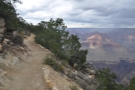 5
5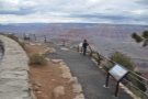 6
6 7
7 8
8 9
9 10
10 11
11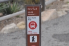 12
12 13
13 14
14 15
15 16
16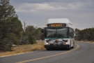 17
17 18
18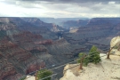 19
19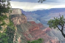 20
20 21
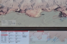
21I had always intended to do a down-and-back hike into the canyon and had set aside the following day, Sunday, so that I could get a full day-hike in, going as far as I could before turning back. While I’d been wandering along the Rim Trail, I’d also been checking out various maps and noticeboards. Reading up about the Grand Canyon ahead of time, the Bright Angel Trail seemed the most accessible and, having checked out the trailhead, I decided that it would be the route for my hike the following day.
By then it was half past one, which gave me about 4½ hours to sunset. Although I was keen to hike down into the canyon and am, by nature, a walker, I was also aware that I hadn’t done any serious hiking in a while. I was also aware that I was at an altitude of 2,000 m, something that I wasn’t used to (to give you a baseline, the highest mountain in the UK, where I live, is Ben Nevis at 1,345 m). With that in mind, I decided that I needed to do a shorter hike, a warmup, so to speak, in readiness for the following day.
I could have gone a little way down Bright Angel Trail, but since I’d be doing it in less than 24 hours, it seemed needless repetition, so I turned instead to the Rim Trail. As well as running east from the village, it also continues west for another 13 km, following the rim all the way to a place called Hermits Rest (which, incidentally, is the trailhead for the Hermit Trail which goes down into the canyon). The Rim Trail is pretty flat, so wouldn’t be too strenuous, but at 13 km, it would be long enough to give me a decent workout and demonstrate whether I had any problems hiking at 2,000 m altitude (the last time I’d been hiking at over 2,000 m was 15 years earlier in the Polish and Slovak High Tatras).
Another bonus is that the Rim Trail to Hermits Rest runs parallel to (and sometimes directly alongside) Hermit Road, which is served by a free shuttle bus (from March 1st to November 30th), with multiple stops along the way. This meant that having walked to Hermits Rest, I could get the bus back. Perhaps more importantly, if it turned out that I did have problems hiking at that altitude, I had plenty of points where I could pull out of the walk and get the bus back. And finally, although 13 km in 4½ hours was a very gentle pace, if I spent too long admiring the views along the way (probably the most likely outcome), I wasn’t committed to making it all the way to Hermits Rest before nightfall.
With all that in mind, I set off. You can read about my hike after the gallery, although the pictures do most of the talking.


 a dry stream bed.")


 flows into the Colorado River at the bottom of the canyon.")


 stop, The Abyss, let's leave it here for now.")
 1
1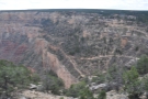 2
2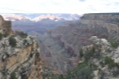 3
3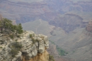 4
4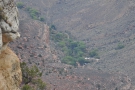 5
5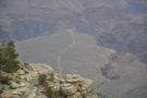 6
6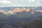 7
7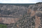 8
8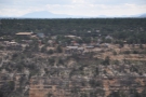 9
9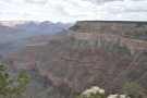 10
10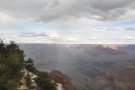 11
11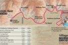 12
12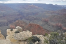 13
13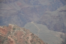 14
14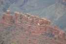 15
15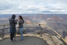 16
16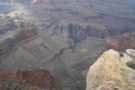 17
17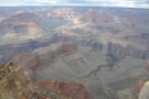 18
18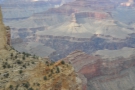 19
19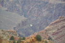 20
20 21
21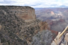 22
22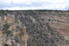 23
23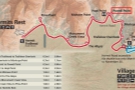 24
24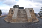 25
25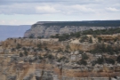 26
26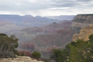 27
27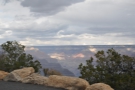 28
28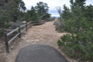 29
29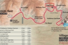 30
30 31
31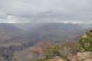 32
32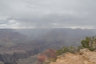 33
33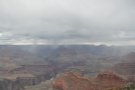 34
34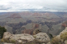 35
35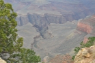 36
36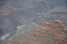 37
37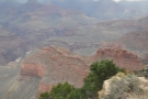 38
38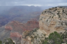 39
39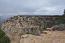 40
40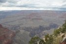 41
41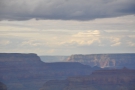 42
42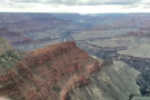 43
43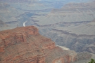 44
44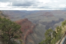 45
45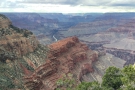 46
46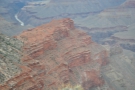 47
47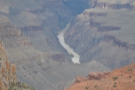 48
48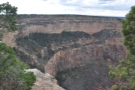 49
49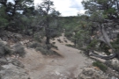 50
50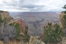 51
51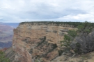 52
52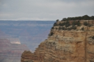 53
53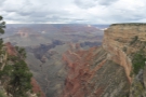 54
54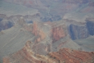 55
55 56
56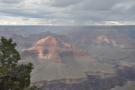 57
57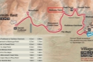 58
58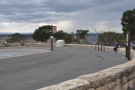 59
59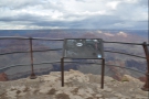 60
60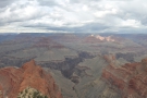 61
61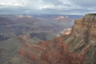 62
62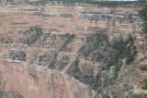 63
63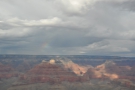 64
64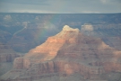 65
65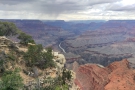 66
66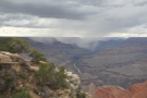 67
67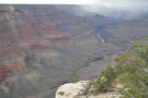 68
68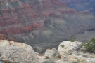 69
69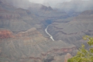 70
70 71
71 72
72 73
73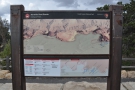 74
74 75
75Although the Rim Trail runs parallel to the road all the way to Hermits Rest, much of the time you don’t feel like you are near the road, which is particularly true at the start, when, just after leaving the Bright Angel Trailhead, the road takes a large loop away from the rim. The Rim Trail, in contrast, stays true to its name and sticks close to the rim, offering great views across to the start of the Bright Angel Trail as its zigzags down the cliffside.
The road re-joins the trail at Trailview Overlook, the site of the first bus stop. From there, the two run north together along the west side of the valley, all the way to Maricopa Point. Note that if you are planning on using the shuttle buses on this section, only outbound buses stop at the first two stops, so to get back to the Grand Canyon Village, you’ll need to take the outbound bus to Powell Point before transferring to an inbound bus.
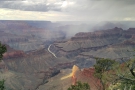
Although there’s a bus stop at Maricopa Point, the actual viewpoint is on a narrow headland to the north, accessed via a 200-metre paved path from the bus stop/road. From there, you have great views north across the canyon as well as to the east and west along the south rim. It’s also where I caught my first glimpse of the Colorado River, running at the bottom of the Grand Canyon, well over 1,000 metres below me.
From Maricopa Point, the Rim Trail turns to go roughly west, following the rim to the next bus stop/viewpoint at Powell Point, where a big loop comes off the road to allow buses in both directions to stop. From here, a 100-metre paved path runs northeast to the viewpoint, where you’ll find the Powell Memorial, a low stone platform that commemorates John Wesley Powell, a geologist who explored the Grand Canyon in 1869.
One thing to note is that as far as Powell Point, the trail is well paved and very easy going. From then on, it really does become a trail, easy enough to hike on, but you’ll need decent footwear at the very least. I carried on, following the trail to Hopi Point, which is on the next headland over, at the eastern side of a deep, steep-sided U-shaped side valley. Like Powell Point, a big loop provides access to the bus stop from the road, but, unlike Powell Point, the viewpoint, which provides some great views of the river in either direction, is right next to the bus stop.
It’s just over 1½ km (or a round mile if you prefer) to the next bus stop, Mohave Point, which is on the western side of the U-shaped valley. This is off another loop from the road, plus a shorter, 50-metre paved path which leads to the viewpoint itself, with more great views of the Colorado River.
Although the viewpoints are fantastic, there are also plenty of views along the way, and I found myself constantly stopping to admire the scenery and to take photographs. And, of course, I also took lots of photographs at the viewpoints themselves. As a result, by the time I was ready to leave Mohave Point, I’d already been going for two hours (out of my allotted 4½ hours), but had covered little more than one third of the distance.
If I was going to reach Hermits Rest before nightfall, I was going to have to pick up my pace (and stop taking so many photographs!). You can see whether I made it after the gallery.


, there's more rain in the canyon.")


 1
1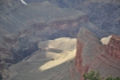 2
2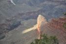 3
3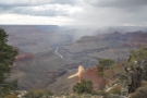 4
4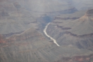 5
5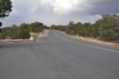 6
6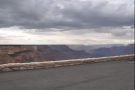 7
7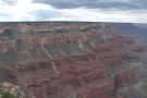 8
8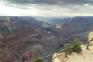 9
9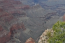 10
10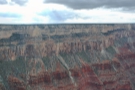 11
11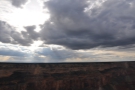 12
12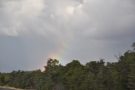 13
13 14
14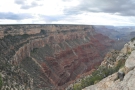 15
15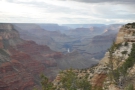 16
16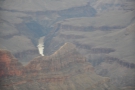 17
17 18
18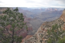 19
19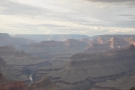 20
20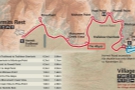 21
21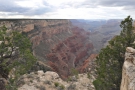 22
22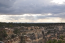 23
23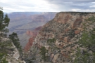 24
24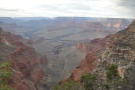 25
25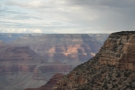 26
26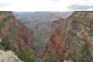 27
27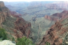 28
28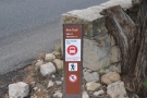 29
29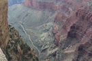 30
30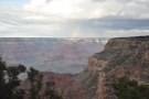 31
31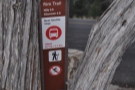 32
32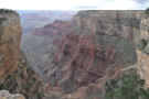 33
33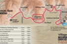 34
34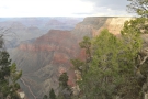 35
35 36
36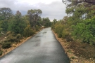 37
37 38
38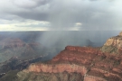 39
39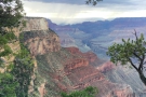 40
40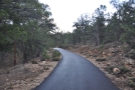 41
41 42
42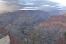 43
43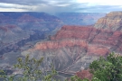 44
44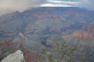 45
45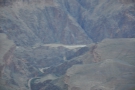 46
46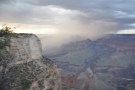 47
47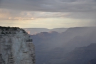 48
48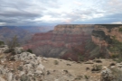 49
49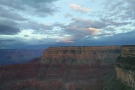 50
50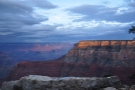 51
51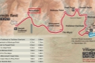 52
52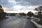 53
53 54
54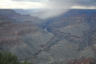 55
55 56
56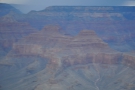 57
57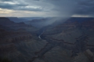 58
58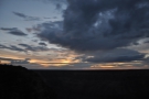 59
59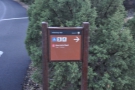 60
60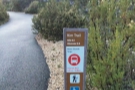 61
61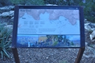 62
62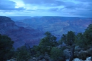 63
63 64
64From Mohave Point, the Rim Trail goes south again, following the top of the Great Mohave Wall, the massive cliff on the eastern side of Monument Creek valley. The trail is between the road and the cliff edge, often running right next to the road, which has several turnouts where you can stop and admire the views (the shuttle buses run from March 1st to November 30th: outside of these dates, private cars can use the road). It’s almost two kilometres from Mohave Point to the next bus stop at The Abyss, so naturally I stopped a few times along the way to admire the views.
The Abyss is at the southern end of the valley and from here the Rim Trail and Hermit Road carry on together to the west, around the tip of the valley to Monument Creek Vista, which is just over 1½ km (or a round mile if you prefer) away. The trail offers great views of the valley, so unsurprisingly, I stopped a few times to take some photographs.
It was, by the way, perfect hiking weather. After the 30°C temperatures in Phoenix, it was a wonderfully cool 12°C on the rim, while several short showers (and attendant rainbows) added to the drama. There’s nothing quite like standing on the rim, watching rain showers blow through the Grand Canyon.
The final stretch of the Rim Trail, from Monument Creek Vista to Hermits Rest via Pima Point, is another 4½ km, and I’d left myself an hour in which to cover it, which was doable if I didn’t dawdle. Fortunately, the trail is paved again beyond Monument Creek Vista, so I made good time. The trail runs northwest, mostly following the rim, but taking a detour inland to avoid a short valley, after which is re-joins the road just south of Pima Point.
Access to the Pima Point bus stop is provided by another large loop, allowing buses in both directions to stop there. The viewpoint is just to the north of the bus stop, with some amazing views directly along the Grand Canyon to the north. There was a bus waiting when I arrived, so I could have ended my hike there, but I had around 20 minutes until dusk and just another 1½ km / mile left, so I decided to press on.
From Pima Point, the trail turns southwest for the final section, running along the rim of a short but steep valley. Again, I made good time, helped by the fading light, which meant that I wasn’t tempted to stop for too many views/photographs. I arrived at Hermits Rest just before six o’clock, where I found another bus waiting for me (the shuttle buses run from an hour before sunrise to an hour after sunset).
After one last look at the Grand Canyon, I got on the bus and was driven back to Grand Canyon Village in style, where I retrieved my car and drove back to my hotel in Tusayan to end a very satisfying day.
This concludes my first day at the Grand Canyon. You can find out how I got on during my down-and-back hike on the Bright Angel Trail in the next instalment of this Travel Spot.
Don’t forget that you can share this post with your friends using buttons below, while if you have a WordPress account, you can use the “Like this” button to let me know if you liked the post.