 My second visit to Arizona’s Apache Trail came towards the end of the same trip in late January/early February 2018. My first visit had been a taster, a short drive to Canyon Lake and back on Monday evening. I’d just flown into Phoenix from Miami and, after two weeks in Florida, was desperate to see the mountains.
I spent the rest of the week in a work meeting, finally escaping on Friday evening. I’d planned to spend the following week in northern Arizona, basing myself in Flagstaff. As on my first visit to Phoenix in October 2016, I could have set off after work on Friday to drive straight up I-17. However, my appetite for the Apache Trail had been whetted, so I decided to stay overnight in Phoenix, giving myself Saturday for a leisurely drive to Flagstaff.
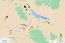
Since I wanted to drive the length of the Apache Trail, the logical route would have been to follow the Apache Trail to Theodore Roosevelt Lake, then take SR 188 and SR 87 north before either following the backroads to Flagstaff or cutting across to I-17 at Camp Verde. Instead, I came up with an ambitious route that I called the Big Loop.
Since this is a very long post, I’ve split it into the following sections:
- Planning my route and the Big Loop
- Driving the Big Loop, Part I
- Driving the Big Loop, Part II
- Back to Canyon Lake
- Fish Creek Hill Viewpoint
- Down into Fish Creek Canyon
- Apache Lake and Theodore Roosevelt Dam
You can read more about the Big Loop after the gallery.

 car.")

.")
 1
1 2
2 3
3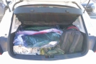 4
4For a long time, my motto as a traveller has been “less is more”, that is, I’d rather see fewer places, but spend more time seeing each one, than trying to run around seeing everything. However, every now and then, I slip back into old habits and try to do far too much in a single day. As you will see, this was one of those occasions.
Since I had all day to drive to Flagstaff, I wanted to make the most of it and see as much of the countryside as possible. With hindsight, I should have just taken the logical route, but instead I decided that I would begin by driving east from my base in Scottdale, picking up SR 87 to follow it north to its junction with the northern end of SR 188. From there, I’d follow SR 188 down to Theodore Roosevelt Lake, the large reservoir at the eastern end of the Apache Trail.
If I’d been sensible, I’d have picked up the Apache Trail at this point, driving it east-to-west, which would have taken me back to Apache Junction. From there I could have either taken SR 87 north or gone north around Phoenix and picked up I-17, repeating my route from October 2016. Either would have got me to Flagstaff in plenty of time.
However, I rejected the idea of this little loop and instead decided to follow SR 188 all the way to its southern end, where it meets US 60 just west of Globe. From there, I would take US 60 back west to Apache Junction, where I’d finally pick up the Apache Trail, which I’d then drive west-to-east all the way back to Theodore Roosevelt Lake. Finally, I’d head north along SR 188 and SR 87 before cutting across to I-17 at Camp Verde for the last leg to Flagstaff. Honestly, it seemed like a good idea when I’d planned it.
In my defence, I was partly fooled by my exploratory drive along the Apache Trail at the start of the week, which had given me a false impression of how easy the going would be. I estimated 1½ hours to get to the eastern end of the Apache Trail via SR 87 and SR 188, another 1½ hours to get to Apache Junction via SR 188 and US 60 and then maybe two hours to drive the trail itself, a total of five hours of driving. I’d probably have to do the last part of the drive up to Flagstaff in the dusk, but that would be fine.
There was one change from Monday: I had a different hire car. The one I’d picked up when I arrived at the airport on Monday morning was rather disappointing. For starters, although I’d specified a compact, it was (to my UK eyes) rather on the large size, although, despite its size, I struggled to fit all my luggage into the boot, which I wasn’t very happy about. Perhaps a more serious drawback, given all the driving that I was planning for the second week, it didn’t have cruise control (I had no idea that you could hire a car without it in the US!).
Fortunately for me, the engine warning light came on as I was driving into the office on Wednesday morning (honestly, I had nothing to do with it, it just came on by itself), so I arranged with the hire car company to return it that evening and instead picked up a Chevrolet Cruze, a compact hatchback with far more room in its boot than its predecessor. And it had cruise control!. Suffice to say I was very pleased!
Come Saturday morning, I packed everything into the boot and got ready to drive the Big Loop, which you can read about after the gallery.


 seems to be on cruise control.")


...")


 1
1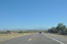 2
2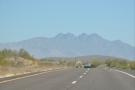 3
3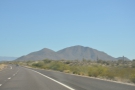 4
4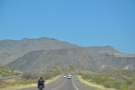 5
5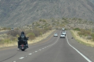 6
6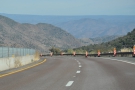 7
7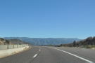 8
8 9
9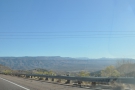 10
10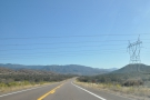 11
11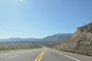 12
12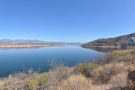 13
13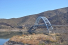 14
14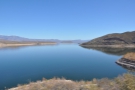 15
15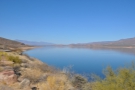 16
16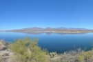 17
17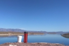 18
18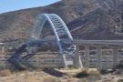 19
19Sunset in Arizona in early February is around six o’clock, and since I’d allowed myself five hours to drive the Big Loop and the Apache Trail, it would have been wise to set off at around 10 o’clock, unless I wanted to be doing the bulk of the drive from Theodore Roosevelt Lake to Flagstaff in the dark. However, regular readers know what I’m like in the mornings, so it should come as no surprise that by the time I’d got up, had breakfast, packed up my room, checked out and got everything into the car, it was 11:30.
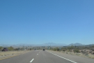
Nevertheless, I was still confident that I had enough time as I set off for the 20-minute drive east along East Shea Boulevard and through the urban sprawl of Scottsdale to pick up SR 87. I made good progress as I headed north, SR 87 reminding me of the drive I took north on I-17 to Flagstaff on my way to the Grand Canyon in 2016. It has the same long, sweeping sections of dual-carriageway road with big, open views, some of which were spectacular, and all of which were interesting. It passes through big mountain country, with scrub and desert on either side and plenty of cacti. It’s definitely worth driving and, if you’re not in a hurry and don’t fancy I-17, it offers an interesting alternative route to Flagstaff (Google Maps estimates it will add an hour to the journey).
After an hour, I reached the junction with SR 188 and turned off, first heading east then south along a long, broad-bottomed valley, effectively running parallel to SR 87 which was off to the west on the other side of the mountains. In contrast to SR 87, it’s a single-carriageway road, but I pretty much had it to myself and made good time, although if I’m honest, it was the least interesting part of the drive.
After another 40 minutes of driving, I’d reached Theodore Roosevelt Lake, where I pulled in for a break, admiring the views (particularly those of the Roosevelt Lake Bridge) and having coffee, which I’d made in my Travel Press back in my hotel that morning. By the time I was ready to get going again, it was 13:30, and, with hindsight, I should have cut out the southern section of the Big Loop and just driven west along the Apache Trail.
Instead, I pressed on, which you can read about after the gallery.


 1
1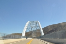 2
2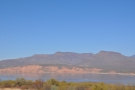 3
3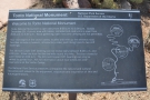 4
4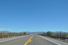 5
5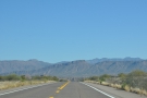 6
6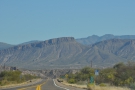 7
7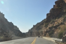 8
8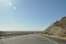 9
9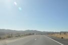 10
10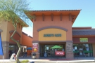 11
11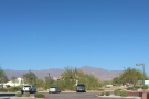 12
12With hindsight, I’m glad that I didn’t cut my journey short at this point, even if it would have been the sensible thing to do. The drive south along SR 188 was impressive, the road climbing out of the valley and into the mountains north of Globe. I suspect that it would be even better coming the other way, dropping down into the valley, the lake spread out ahead of you. As it was, I had to make do with some spectacular views in my rear-view mirror.
The drive through the mountains at the head of the valley was also impressive, but the section to the west of Globe, where it joins US 60, and the drive through Claypool and Miami (ironic, given that I was in Miami, Florida the weekend before) is a bit grim. This is active mining country and it shows, with slag heaps and still-working open cast mines abound.
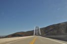
However, it’s worth pressing on to the west, where the road narrows to single carriageway, following a narrow, steep-sided gorge through the mountains, dropping down from a place called (appropriately) Top-of-the-World to Superior. The road descends from an elevation of nearly 1,400 m to just under 900 m in 14 km. Along the way, there are some amazing sheer cliffs, a magnificent bridge and an impressive tunnel. Although I went east-to-west, I suspect the climb from west-to-east would be just as glorious.
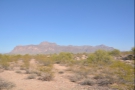
West of Superior, the landscape opened out into flat scrub/desert, surrounded by mountains (basically what I’m used to around Phoenix), although as I drove west, I had some great views of the mountains. By now, it was three o’clock, so I stopped just before I reached Apache Junction at a small town called Gold Canyon, where I had a late lunch at Janie’s Café (which has since been sold and is now Waffle On Inn).
At 15:30, I was on the road again, heading for the Apache Trail, which you can read about after the gallery.


 takes in the views across the lake.")


 1
1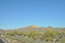 2
2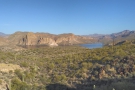 3
3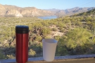 4
4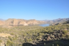 5
5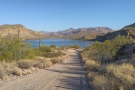 6
6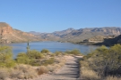 7
7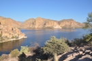 8
8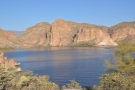 9
9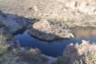 10
10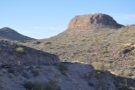 11
11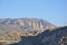 12
12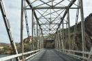 13
13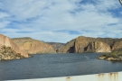 14
14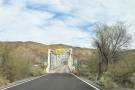 15
15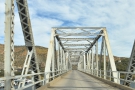 16
16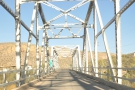 17
17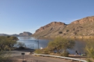 18
18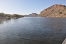 19
19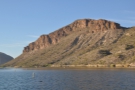 20
20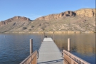 21
21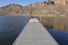 22
22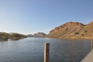 23
23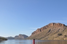 24
24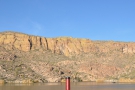 25
25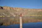 26
26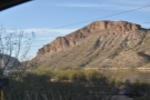 27
27To get from Gold Canyon, where I’d stopped for lunch, onto the Apache Trail, I first had to drive northwest along US 60 to the outskirts of Apache Junction. Here I could cut north a few blocks to pick up SR 88, aka the Apache Trail, as it heads northeast towards the mountains.
In theory, with it taking two hours to drive the full length of the Apache Trail, I should have reached the Theodore Roosevelt Dam just before nightfall. However, knowing that I would want to stop several times along the way, and having driven this first section just six days earlier, I pressed on, not stopping to look around.
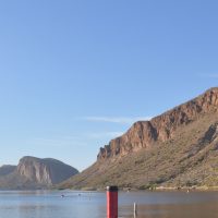
I reached Canyon Lake Vista just after four o’clock and couldn’t resist pulling over to admire the views again. I still had a little coffee left in my Travel Press, so I drank that overlooking the lake and then drove down, almost to the lake shore, parking up at the top of the sideroad I’d discovered on Monday. From there I had some great views across the lake to the north shore, where I was almost directly opposite the point where the Salt River flows into the lake from the north.
Incidentally, the Salt River flows out just a little way to the west of that, with the bulk of the lake filling the valley to the south and east. Before the dam was built, this must have been quite the valley, the river forming a big loop in the northwest corner and the likes of First Water Creek and Boulder Creek flowing in from the southwest and southeast respectively.
Aware that time was pressing on, I got back in the car and crossed the bridge over First Water Creek, which was as far as I had got on Monday. From this point onwards, it was all new to me. The road follows the line of the southern shore for a short while, with plenty of places where you can pull off. It then climbs a little, maybe running 100 to 200 metres back from the shore, before reaching a second bridge across Boulder Creek. In all, it took me under five minutes to make the leisurely drive between the bridges.
The second bridge is at the eastern end of the lake, where all the facilities are, including several hiking trails, a marina, campground, beaches and plenty of car parks. Perhaps the biggest draw is the Dolly Steamboat, which runs daily cruises on the lake. However, there was no time for that on this particular drive, so after another stop to admire the views and get a little creative with my Travel Press, I was on my way again, driving east into the mountains and the really wild part of the Apache Trail.
You can see what I made of it after the gallery.


.")


 mountains to the north...")


.")


.")

.")


.")


 is descending into the canyon, while in the distance...")


 1
1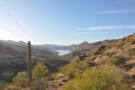 2
2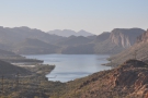 3
3 4
4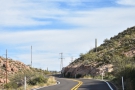 5
5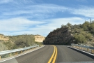 6
6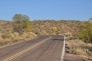 7
7 8
8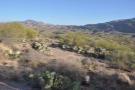 9
9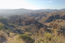 10
10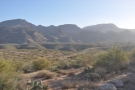 11
11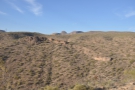 12
12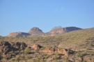 13
13 14
14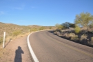 15
15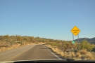 16
16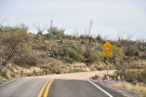 17
17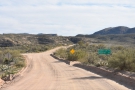 18
18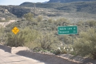 19
19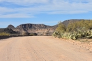 20
20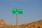 21
21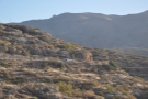 22
22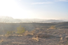 23
23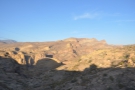 24
24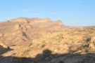 25
25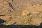 26
26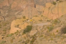 27
27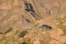 28
28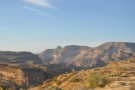 29
29 30
30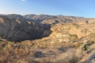 31
31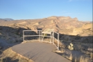 32
32 33
33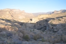 34
34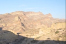 35
35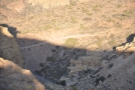 36
36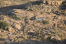 37
37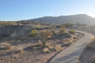 38
38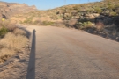 39
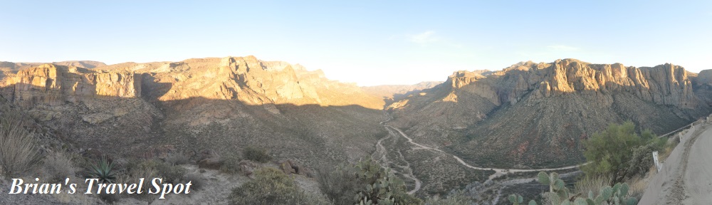
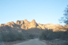
39From the eastern end of Canyon Lake, the Apache Trail climbs up out the valley, offering some glorious views in the rear-view mirror. I suspect that it would be even better coming the other way, dropping down out of the mountains and into the valley with the lake spread out below. Fortunately, there are a few places where you can pull over, including one at the top of the valley where a short access road leads to a telecommunications mast.
I made the most of the opportunity, getting out to take in the views, before carrying on. From the top of the valley, the road passes through Tortilla Flat, where you’ll find a saloon, gift shop and general store in a row of shops on the right, your final chance to stock up on the Apache Trail (or your first chance if you’re coming the other way).
Leaving Tortilla Flat behind, the road climbs up into the mountains, winding its way through some amazing wildness scenery. There are plenty of places where you can pull off the road to admire the views and, naturally enough, I did, although the photographs don’t justice to the area’s rugged beauty.
After some long, sweeping curves and some tight, hairpin bends (this is one road where if there’s a 10 mph advisory speed sign, you know that they mean it!), a dirt track (SR 80) turns off to the left. This winds all the way down to the Salt River, providing access to the Horse Mesa Dam, which is at the western end of Apache Lake, but I don’t know whether it is publicly accessible.
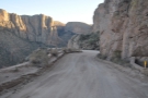
Back on the Apache Trail, there’s another hairpin bend, then the road continues its climb into the mountains, following the southern edge of a valley which I’ve since realised is Fish Creek Canyon as it cuts its way northwest through the mountains to the Salt River. Although the route generally goes west-to-east, at this point the road turns south to avoid a steep-sided side canyon to the east that runs north into Fish Creek Canyon.
Shortly afterward, the Apache Trail abruptly turns into a dirt road, which, I must confess, came as something as a surprise to me as I hadn’t done my homework, assuming that the entire route was paved. Driving on unpaved roads is not something I have a lot of experience of, and I did consider turning back. However, reasoning that the road must be passable since it’s shown as a through route on Google Maps, I pressed on, although driving on a dirt road really slowed me down (note that at the time of writing, the road is closed east of Tortilla Flat due to landslides).
The road continues south for around a kilometre, reaching the Tortilla Trailhead, where it rounds the head of the side canyon. From there, it climbs to the northeast along the eastern side of the side canyon via a series of switchbacks until it reaches Fish Creek Hill, where there’s a small car park, toilet block and some information boards.
If you only have time for one stop on your drive along the Apache Trail, then I recommend that you make it at Fish Creek Hill. There are some great views to the south and west, looking back along the Apache Trail, while to the north, you can see the road as it disappears over the edge of Fish Creek Canyon, the most hair-raising part of the drive. If you have time, a short path on the far side of the car park leads north to a small gazebo/lookout, continuing another 100 metres to a second viewpoint towards the tip of the ridge.
Although I was running short on time, I went out to the more distant viewpoint, then hurried back to my car. It was 17:20, the sun was already dropping towards the western horizon and I still had quite a way to go.
You can see how my descent into Fish Creek Canyon went after the gallery.


 1
1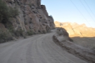 2
2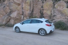 3
3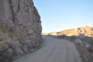 4
4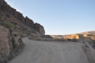 5
5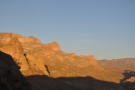 6
6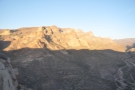 7
7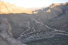 8
8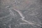 9
9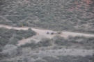 10
10 11
11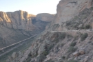 12
12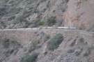 13
13 14
14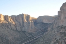 15
15 16
16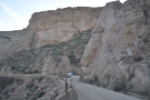 17
17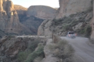 18
18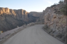 19
19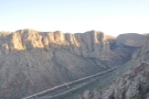 20
20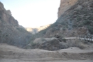 21
21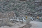 22
22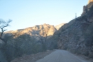 23
23I’d originally allowed myself three hours to drive the Apache Trail, assuming two hours driving, with another hour spread across the various stops. I’d reached the start of the Apache Trail at 15:30 and initially made good progress, reaching Fish Creek Hill not long after five o’clock. I’d lingered there perhaps longer than I should, partly fooled by the fact that I only had another 32 km to go. I mean, how long would that take? After all, I’d done the first 32 km (Fish Creek Hill is pretty much the half-way point) in under an hour’s driving.
I figured that by leaving Fish Creek Hill at 17:20, I could reach the end of the Apache Trail in 40 minutes at most, particularly if I didn’t stop. What I hadn’t taken into account is that for the rest of the way, the road was unpaved. Maybe if I was more experienced in driving on unpaved roads, it wouldn’t have slowed me down as much. There were certainly straight, flat sections where I was able to get up to a decent speed (~60 km/h) but most of the time I was doing more like 20 – 30 km/h as I drove carefully along, making sure that I didn’t put a wheel over the edge, hit a pothole or run into another car coming around a blind bend.
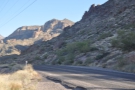
The other thing that slowed me down was the descent into Fish Creek Canyon. Put simply, this is one of the most hair-raising drives of my life. From the carpark at Fish Creek Hill, the road continues northeast for a short way, descending via a series of sharp bends until it rounds a headland at the top of the canyon. At this point, the canyon runs south to north, with the floor of the canyon about 200 metres below.
To get there, the Apache Trail heads due south for about a kilometre, the road clinging to the side of the canyon as it descends to the bottom, where it goes around a hairpin bend, crossing Fish Creek on a sturdy bridge made of steel girders. However, this description barely does it justice since the western side of the canyon is effectively a cliff and the road (unsurfaced, remember) just a single lane with plenty of blind bends and with traffic going in both directions!
With very few exceptions, there are no barriers on the side of the road. You either have bare rock to your right (on the way down) and a very steep drop to your left with nothing more than small dirt bank between you and oblivion. Even in the places where there are safety barriers, these are no more than half a metre tall…
As a result, I drove very, very slowly on my way down, taking over five minutes to get from top to bottom (and that was all driving time). I also stopped for five minutes near the top of the canyon to admire the views! When I got to the bottom, I would have loved to have got out and explored, but time was pressing, so I carried on, the road heading north along the bottom of the canyon.
You can see how the rest of the drive went after the gallery.


, you can see...")


 1
1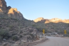 2
2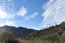 3
3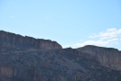 4
4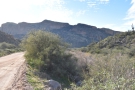 5
5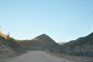 6
6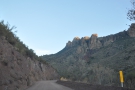 7
7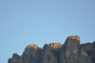 8
8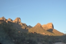 9
9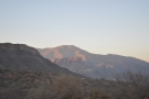 10
10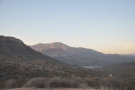 11
11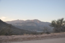 12
12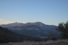 13
13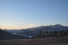 14
14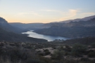 15
15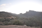 16
16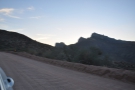 17
17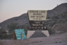 18
18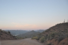 19
19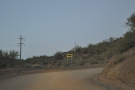 20
20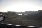 21
21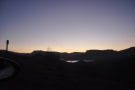 22
22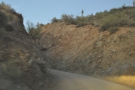 23
23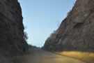 24
24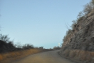 25
25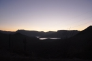 26
26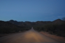 27
27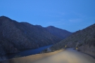 28
28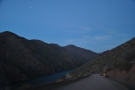 29
29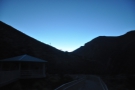 30
30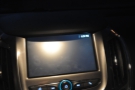 31
31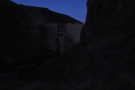 32
32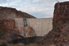 33
33After my descent into Fish Creek Canyon, it took me almost exactly an hour to cover the rest of the Apache Trail, reaching the Theodore Roosevelt Dam at 18:30. Although I stopped a few times along the way to take photos, it was never for more than a minute or two, so it was mostly all driving time.
After its descent, the Apache Trail doubles back on itself, heading north as it follows Fish Creek Canyon for a kilometre. Here another creek, the Lewis and Prantry Creek, flows into Fish Creek Canyon from the east. While Fish Creek continues to carve its way north through the mountains to Salt River, the Apache Trail turns east, following the bottom of the comparatively broad valley formed by Lewis and Prantry Creek. The road follows the valley as it narrows, slowly climbing back into the mountains before turning northeast and coming out into more open country high above Apache Lake.
Apache Lake, created by the Horse Mesa Dam to the west, is long and thin, running roughly west to east for at least 10 km (it’s hard on a map to see where the Salt River ends/Apache Lake starts). Just around where you get your first view of the lake, an unpaved road branches off to the left, running down to a fairly substantial marina and resort on the lake shore. However, if you do want to visit the lake (I had no time on this drive), keep going and, after about a kilometre, a large sign points to the left, where there’s a viewpoint, with great views over the lake, plus a paved road which descends to the marina/resort.
From here, the Apache Trail descends, straight and flat, roughly following the line of the lake/river, but just as you think you might be on the home stretch (and, since it was 17:50, I thought I might make it to the end of the Apache Trail in something approaching daylight), the road climbs again, twisting and turning through narrow, steep-sided valleys, with occasional views of the lake/river, some of which are off to your right as the road takes another switchback.
After about twenty minutes of this, the road hits another long, straight section, making a final descent to the river, which I reached just as it got really dark. From here, the road follows the bottom of the valley, pretty much running along the river’s edge. After another 15 minutes of driving, now in almost complete darkness, I reached the car park at the end of the Apache Trail, where, had I been able to see it, I would have enjoyed some spectacular views of the Theodore Roosevelt Dam.
So that was the end of my drive along the Apache Trail. I believe I could have done it in two hours if I hadn’t stopped to admire the views, but as it was, three hours was pushing it, especially as I’d done the last 30 minutes in dusk then darkness. If, like me, you want to stop and admire the views, I’d allow at least four hours for a leisurely drive.
Of course, while that was the end of the Apache Trail, it wasn’t the end of the day’s driving for me, since I still had to reach Flagstaff! This was another three hours of driving, retracing my route north on SR 188, then going north on SR 87, which took me up to Payson, where I broke my journey for dinner. Carrying on, I went northwest on SR 87/260 as it climbed through the mountains, before cutting west along SR 260 to drop down to Camp Verde, where I picked up I-17 for the last stretch to Flagstaff.
This concludes The Apache Trail and the Big Loop, which turned out to have been an overly ambitious drive for a single day. I would like to do the drive north to Flagstaff in daylight at some point, particularly the section north of Payson. The drive also left me with a sense of unfinished business since I’d driven the last stretch of the Apache Trail in darkness.
As a result, when I returned to Arizona the following year, and took a road trip through eastern Arizona and southern New Mexico, I made sure that it began with a drive along the Apache Trail, which you can read about in the final instalment of this Travel Spot.
If you liked this post, please let me know by clicking the “Like” button. If you have a WordPress account and you don’t mind everyone knowing that you liked this post, you can use the “Like this” button right at the bottom instead. [bawlu_buttons]
Don’t forget that you can share this post with your friends using buttons below.