 I’m not sure how much it comes across in my Travel Spots, but I’m not a great fan of driving. I drive when I must, but see it as a method of getting from A to B. Even on my big road trips, like 2017’s Grand Adventure, my week-long drive from Phoenix to San Francisco via Joshua Tree National Park, Los Angeles and the Californian coast, although I thoroughly enjoyed the drive, I can’t say I enjoyed the driving.
With that in mind, it says something when I actually recommend a drive. One such recommendation is Arizona’s Apache Trail, a steep, twisting road that follows an old stagecoach route through the Superstition Mountains east of Phoenix, a tortuous drive full of breathtakingly views. Sadly, in the summer of 2019, a massive wildfire, followed that September by floods, caused severe damage to the Apache Trail, forcing the closure of large sections of the road. When it will reopen is not clear.
I’ve driven some/all of the Apache Trail three times, twice on the same trip in January/February 2018 and again when I returned to Arizona the following January. Today’s Travel Spot is all about my first visit to the Apache Trail.
Although this is a fairly short post (by Travel Spot standards), for consistency, I’ve split it into three parts:
- introduction to the Apache Trail
- my first taste of the trail: Phoenix to Canyon Lake
- the drive back: Canyon Lake to Phoenix
You can read more about the Apache Trail after the gallery.


 1
1 2
2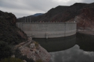 3
3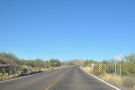 4
4 5
5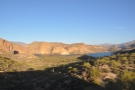 6
6 7
7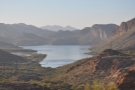 8
8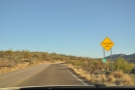 9
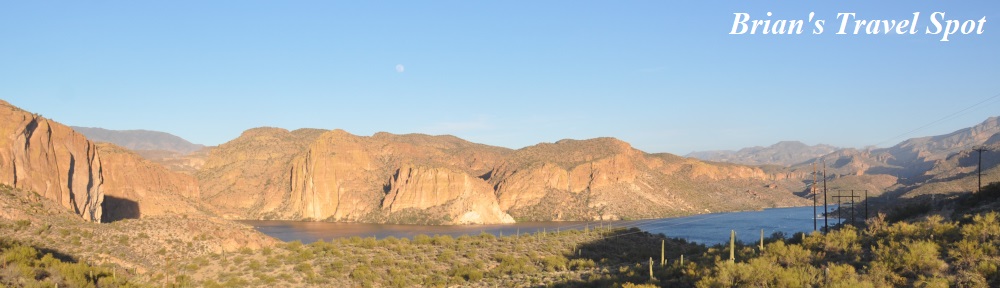
9The Apache Trail, or, to give it its proper title, State Route (SR) 88, connects the town of Apache Junction, east of Phoenix, with Theodore Roosevelt Lake to the northeast, where it joins up with SR 188. Theodore Roosevelt Lake is a reservoir, created by the damming of the Salt River in 1911. SR 88, which follows an older stagecoach route through the mountains, was built in 1904 to provide access during the dam’s construction.
From Apache Junction, which can be reached by driving east from Phoenix on US 60, the Apache Trail heads northeast along the bottom of a broad valley, slowly climbing as it goes. There are several turnouts and car parks on this section of the road, but once you pass the Horse Trails Trailhead and Weaver’s Needle Vista Viewpoint, it suddenly starts to climb steeply via a series of switchbacks.
From there, the Apache Trail drops down to Canyon Lake, another reservoir on the Salt River, which was completed in 1925. The road passes through Tortilla Flat before climbing via a series of broad sweeping curves. Near the top, the road, which is paved up to this point, turns into a dirt track (if, like me, you are driving a hire car, just make sure you can drive on unpaved roads, since some hire car companies explicitly exclude this). The road gets steeper, climbing to the Fish Creek Hill Viewpoint before dropping down the side of Fish Creek Canyon, which is not a drive for the faint-hearted!
From Canyon Lake, the eastern section of the Apache Trail follows the route of the Salt River, which flows westwards through the mountains on its way to Phoenix. However, while following the route of the river, the road rarely follows the river itself, such is the nature of the terrain. Instead, it climbs and winds through the mountains to the south of the river.
After the descent into Fish Creek Canyon, you get occasional glimpse of the river, particularly from Apache Lake Vista, where a paved road leads down to the marina and resort on Apache Lake, yet another reservoir, this one created in 1927. There’s also a dirt track to the marina/resort, which peels off about a kilometre before the paved road. From the vista, the road continues high above the river before eventually dropping down to the bottom of the narrow valley a few kilometres from the Theodore Roosevelt Dam and its junction with SR 188.
Although just 65 km in length, it took me over three hours to drive the Apache Trail, including stops. It probably took me over two hours of actual driving time, although I’m sure you can drive it a little faster, since I was being extra cautious. This is largely down the twists and turns of the road, plus the need to avoid numerous potholes in the unpaved section!
Naturally, you’ll want to allow time if, like me, you are going to stop to admire the views. If I was doing it again, I’d want to allow at least four hours to full enjoy both the drive and to allow for numerous stops.
I’ve driven on the Apache Trail on three separate occasions, starting one afternoon at the end of January 2018. This was very much a taster and I only went as far as Canyon Lake, returning in the fading evening light, a drive you can still do despite the road closures. My appetite whetted, I returned to the Apache Trail a few days later, this time to drive its full length, something you can’t currently do, since the road is closed between Tortilla Flat and Apache Lake. However, I misjudged how long it would take, completing the last section (from Apache Lake Viewpoint to Theodore Roosevelt Lake) in the dark.
As a result, when I returned to Arizona in January 2019, I drove the Apache Trail for a third time, setting off much earlier in the day on this occasion so that I could complete the entire drive in daylight. Once again, I went west to east and it remains an ambition of mine, when the road is fully reopened, to drive it a fourth time, but going from east to west for once!
You can read about my first drive, to Canyon Lake and back, after the gallery, while the second instalment of this Travel Spot covers my end-to-end drive later that trip. The third instalment, meanwhile, is all about my return in January 2019.


 stop was at Apache Gap. This is the view north, where the road...")


...")


.")

.")


 1
1 2
2 3
3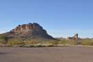 4
4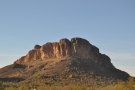 5
5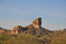 6
6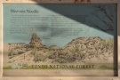 7
7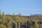 8
8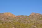 9
9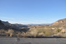 10
10 11
11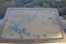 12
12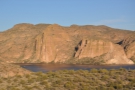 13
13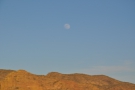 14
14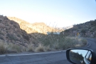 15
15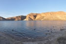 16
16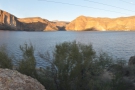 17
17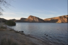 18
18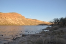 19
19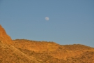 20
20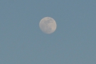 21
21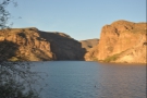 22
22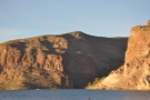 23
23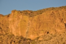 24
24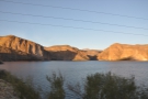 25
25My first drive along the Apache Trail came midway through a month-long trip to Florida and Arizona at the start of 2018. It was Monday afternoon and I’d just arrived in Phoenix following an early-morning flight from Miami, picking up my hire car at the airport. After two weeks in Florida, where everything had been as flat as a pancake, I wanted to see the mountains! However, my meeting was due to start next morning, so I couldn’t go very far, which is why I settled on the drive out to the Superstition Mountains along the Apache Trail.
I headed south from my base in Scottsdale, then went east on US 60 until I reached Apache Junction. SR 88 is easy to find and soon I was heading northeast, leaving the urban sprawl of the greater Phoenix area behind. I passed the Goldfield Ghost Town, a wild west theme park, where you’ll find an old gold mine and a narrow-gauge railway among the attractions, and the Lost Dutchman State Park, which has numerous hiking trails.
Either of these attractions could have caught (and held) my attention on another day, but I pushed on, past the Horse Trails Trailhead before reaching Weaver’s Needle Vista Viewpoint, where I turned into the car park for my first view of the mountains. Weaver’s Needle, by the way, is an impressive outcropping of rock that stands about 15 km away to the east. It’s accessible via a hiking trail (another starts at the Lost Dutchman State Park), but it’s really a day-long hike there and back (and not something for a Monday evening!).
After drinking in the views, I got back in my car and carried on. The road heads north and starts to climb via a series of switchbacks until it reaches Apache Gap at the top of the valley. From here, you get the briefest of views of the route ahead, the road swiftly descending through the mountain wilderness as it drops down towards the Salt River. There aren’t many stopping places here, but I pretty much had the road to myself, so managed to stop on the side of the road for a couple of quick photos before carrying on.
Near the bottom, there’s a great turnout and car park on the right, with some excellent views of Canyon Lake. Appropriately enough, it’s called Canyon Lake Vista and is definitely worth a stop. The road carries on down to the lake via a big, sweeping curve, although there is a turning that heads north to the Mormon Flat Dam at the western end of the lake (I don’t know if it is open to the public).
There is quite a bit going on at the eastern end of Canyon Lake, including beaches, a marina, campsites, restaurants and a paddle steamer! However, it was quite late in the evening, so I stopped soon after reaching the western end of the lake, which was as far as I got that day. After stretching my legs and taking in the views, I turned around and headed back the way I’d come.
You can read about my drive back after the gallery.


 1
1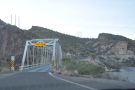 2
2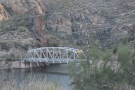 3
3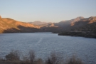 4
4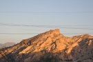 5
5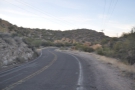 6
6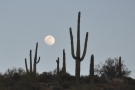 7
7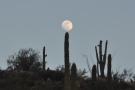 8
8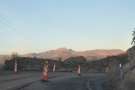 9
9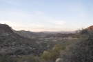 10
10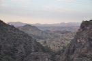 11
11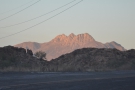 12
12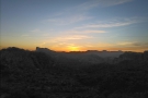 13
13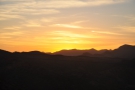 14
14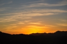 15
15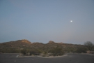 16
16 17
17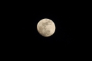 18
18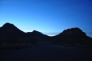 19
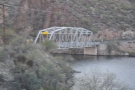
19I’d stopped just after crossed a short bridge over an inlet on the southern side of the lake, which was pretty much the first opportunity I had. Turning around, I drove back over the bridge and followed the road back to the where it joined the lake. On my drive down, I’d spotted a short side road on the left-hand side, but, wanting to get to the lake itself, I’d carried on. Now, with a little more time to spare, I pulled over and got out to take a look. There’s a gate at the start of the road, it wasn’t far to the lake shore, so I wandered down to where a simple landing stage offers views right along the length of Canyon Lake.
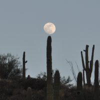
Returning to my car, I set off for the drive back up to Apache Gap, this time giving Canyon Lake Vista a miss. The drive down had some spectacular but fleeting views, the road constantly passing through short valleys. It was when I driving back up one of these that I noticed the moon rising over the valley rim to my left. Fortunately, this section of road has plenty of turnouts, so I pulled over once more, rewarded (after some careful positioning) with a view of the full moon sitting on the top of a cactus, not something I’d ever thought I’d see.
Carrying on, I drove up to Apache Gap where I found somewhere to pull over right at the top (I’d not been able to stop there on the drive in due to temporary barriers along the centre of the road, the result of some resurfacing work, I think). Again, I got out to stretch my legs and drink in the views before setting off again.
I had planned my next stop to be back at Weaver’s Needle Vista Viewpoint, where I’d started my exploration of the area, but a spectacular sunset caught my attention, causing me to pull over (again!) so that I could watch the sun setting behind the mountains to the west. Fortunately, I made it to Weaver’s Needle Vista Viewpoint without further interruption, where I took some photographs of the full moon (and cursed myself for not bringing my big zoom lens with me).
I did consider staying until the stars came out, which, I suspect would have been quite spectacular, particularly looking to the east, away from Phoenix. However, I’d had a long day, having been up at 04:45 that morning to catch my flight from Miami (the equivalent of 02:45 in Phoenix!). It was 18:30 by the time I returned to Weaver’s Needle Vista Viewpoint and tiredness got the better of me. Knowing that I had to be up the next morning for work, I bade a reluctant farewell to the Apache Trail, driving back to my hotel in Scottsdale for dinner and an early night.
That concludes the first part of the Apache Trail. However, my appetite for the Apache Trail was well and truly whetted. The following Saturday I was back, this time to drive the trail from end-to-end, which you can read about in the next instalment of this Travel Spot.
If you liked this post, please let me know by clicking the “Like” button. If you have a WordPress account and you don’t mind everyone knowing that you liked this post, you can use the “Like this” button right at the bottom instead. [bawlu_buttons]
Don’t forget that you can share this post with your friends using buttons below.