 In 2018 and 2019 I made three visits to Arizona’s Apache Trail, an amazing road through the Superstition Mountains to the east of Phoenix, built in 1904 to provide access to the Theodore Roosevelt Dam, which was at that point under construction on the Salt River. The first two visits were during the same trip in January/February 2018, an initial taster drive to Canyon Lake and back, followed by driving the full length of the Apache Trail later on that week.
However, my love affair with the Apache Trail wasn’t over. On the second drive, I’d been over-ambitious, underestimating how long it would take to drive from end-to-end, which meant that I did the last part, from Apache Lake to the dam, in the dark. That left me with a sense of unfinished business, so on my return to Arizona in January the following year, I made driving the Apache Trail in daylight a priority.
As I had the previous year, I first spent a week in Phoenix for work, then hit the open road, this time on a week-long excursion through southern Arizona and New Mexico, starting with my drive along the Apache Trail.
Since this is a fairly long post, I’ve split it into the following parts:
You can see how I got on at Saguaro Lake after the gallery.


 fit everything into the boot.")


.")


 is Canyon Lake Vista.")
 1
1 2
2 3
3 4
4 5
5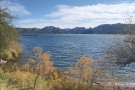 6
6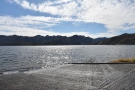 7
7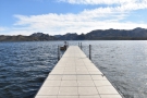 8
8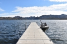 9
9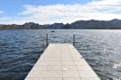 10
10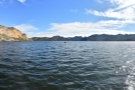 11
11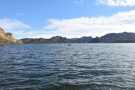 12
12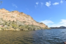 13
13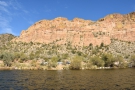 14
14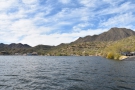 15
15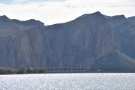 16
16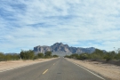 17
17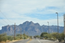 18
18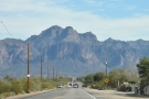 19
19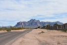 20
20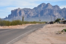 21
21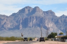 22
22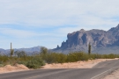 23
23 24
24As I had the previous year, I spent Friday night in Phoenix, then set off on Saturday morning. This time I had even less daylight to play with, since it was early January rather than early February, plus I’d learnt my lesson regarding over-ambitious planning. My ultimate goal was to reach the mining town of Globe (where I would be spending the night) by Saturday evening. This is about a 45-minute drive from the Theodore Roosevelt Dam at the eastern end of the Apache Trail, so I planned backwards from there, deciding that I had enough time for a short detour at the start of my journey.
Despite my best endeavours, it wasn’t until 11:45 that I set off, having first grabbed a last coffee from Maverick, a lovely coffee shop in the outdoor mall next to my hotel in Scottsdale. Typically, to get to the start of the Apache Trail (otherwise known as SR 88), I’d take SR 101 south, then US 60 east to Apache Junction, but, since I had a little spare time, I struck out due east along East Shea Boulevard, all the way to SR 87, which is how, 11 months earlier, I’d started the drive I called The Big Loop.
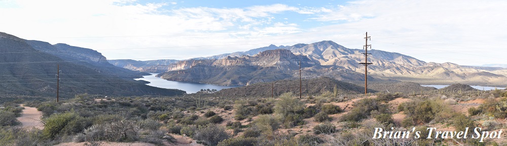
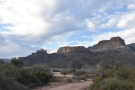
On that occasion I’d driven north along SR 87, all the way to its junction with SR 188. This time I was still going north, but for just 15 minutes, until I reached the Bush Highway. This heads south, climbing into the mountains on its way to Saguaro Lake, which I reached in under 10 minutes. Created by the construction of the Stewart Mountain Dam in 1930, Saguaro Lake is the fourth reservoir on the Salt River, following (from east/upstream to west/downstream) Theodore Roosevelt Lake, Apache Lake and Canyon Lake, all of which I had already seen/visited. You might say that I was collecting the set.
I drove down to the water’s edge and spent a few minutes admiring the views before setting off again. Canyon Lake, where the Apache Trail first reaches the Salt River, is just 8 km east of where I was as the crow flies, although it’s more like 14 km as the Salt River flows. However, neither flying nor paddling up the river were options, so I was back on the Bush Highway.
From Saguaro Lake, the road runs west out of the mountains, roughly following the line of the Salt River. I could have taken it all the way to its junction with SR 202, then taken that US 60 to Apache Junction. Instead, I cut south over Usery Mountain on the Usery Pass Road, a wonderful drive which brought me out on the northern edge of Mesa. From here, it was a simple job to drive east along Brown Road and Lost Dutchman Boulevard, skirting the northern edge of Apache Junction until I picked up the Apache Trail.
This was the first time I’d approached the Superstition Mountains from this direction and it was amazing how abruptly they seemed to rise up from an otherwise flat landscape, something that was even more apparent when I flew over the area almost exactly a year later on my way from Phoenix to Portland, Maine.
I was already familiar with the drive in and the climb up and over Apache Gap, so I didn’t stop this time, but if you want, you can look at the photos from first drive in 2018. From Apache Gap, the road drops down to Canyon Lake and, just as I did when I drove the Apache Trail from end-to-end in 2018, I couldn’t resist pulling over at Canyon Lake Vista for my first view of the lake. Back then it was four o’clock in the afternoon by the time I reached the vista, whereas this time it was a much more reasonable 13:30, the drive from Saguaro Lake having taken 45 minutes, my roundabout route covering a mere 50 km…
You can see what I got up to at Canyon Lake and beyond after the gallery.


 catfish and fries, served in a basket.")


 where I'm going next.")
 and over Fish Creek Canyon.")


 is 22 miles, I know it's going to take me a couple of hours!")
 1
1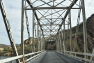 2
2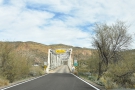 3
3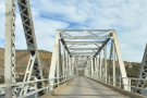 4
4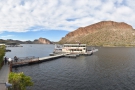 5
5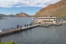 6
6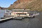 7
7 8
8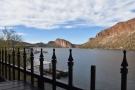 9
9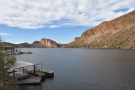 10
10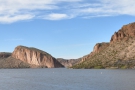 11
11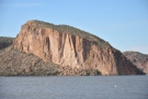 12
12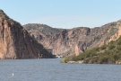 13
13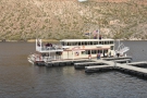 14
14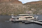 15
15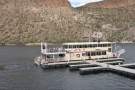 16
16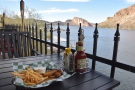 17
17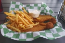 18
18 19
19 20
20 21
21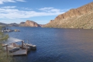 22
22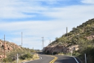 23
23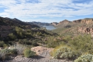 24
24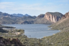 25
25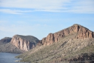 26
26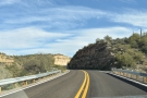 27
27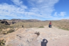 28
28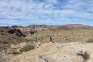 29
29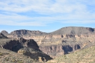 30
30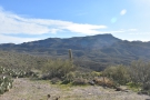 31
31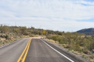 32
32 33
33 34
34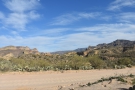 35
35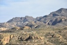 36
36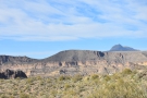 37
37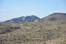 38
38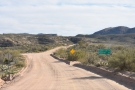 39
39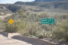 40
40Having explored the western end of Canyon Lake when I visited in 2018, I drove straight down from Canyon Lake Vista and followed the Apache Trail as it made its way along the lake’s southern shore, only stopping once I’d crossed Boulder Creek at the Canyon’s eastern end. This is where all the facilities are, including several hiking trails, a marina, campground, beaches and plenty of car parks. I pulled into the largest of these, immediately on the left after the bridge, which serves a number of facilities, including the Dolly Steamboat, which runs daily cruises on the lake.
Sadly, I didn’t have time to take a cruise, but on my previous drive in 2018, I’d noticed that there was a restaurant here, the Well Done Grill, which has an excellent lakeside location, overlooking the pier where the Dolly Steamboat ties up. I’d timed my arrival perfectly, reaching the grill just before two o’clock, which meant that I’d missed the main lunchtime rush and was able to get a seat on the terrace. This offers some wonderful views along the length of Canyon Lake, all the way to the Mormon Flat Dam at the lake’s western end. I decided to have fish and chips, served in a basket with two fillets of battered catfish which may have come from the lake.
I’ll be honest: while the food wasn’t bad, it was the views that I had principally come for, although the service was also very efficient! This allowed me to be on my way by 14:30, zipping past the Laguna Boat Ramp, where I’d stopped the previous year, and driving up the Apache Trail as it climbed into the mountains above the lake’s eastern end. Just as on my drive the year before, I was captivated by the views in my rear-view mirror, so I pulled in at roughly the same spot (by the telecommunications tower) to take in the views back down the valley.
Then it was back in the car and on my way again. I had meant to drive all the way to Fish Creek Hill without stopping, but the beauty of the mountain landscape got the better of me. Twenty minutes after cresting the top of the valley and having driven through Tortilla Flat, I was well into the wilderness portion of the mountains. Despite my best intentions, I pulled over to admire the landscape once again, stopping just before the paved road came to an end. Although I didn’t know it at the time, I was looking north over Fish Creek Canyon as it cuts its way northwest through the mountains on its way to the Salt River.
The Apache Trail drops down into the canyon a little way to the east of where I was, although to get there, the road effectively follows a W (I was at the top left/northwest corner of the W at this point), first going south, then coming back north to Fish Creek Hill to avoid a side canyon. Meanwhile, the second part of the W goes down to the bottom of Fish Creek Canyon before returning north along the canyon’s bottom (there’s a better description from the drive I took last year).
Aware of the time, I carried on, but didn’t get that far, once again being seducing by the views, this time stopping a little further to the south on the unpaved section of the road, where I had a good view across the side canyon to the Fish Creek Hill carpark, where I was going next, before my descent into Fish Creek Canyon.
You can see how that went after the gallery.
 stop was Fish Creek Hill, from where the Apache Trail...")


.")

 side of Fish Creek Canyon.")


 1
1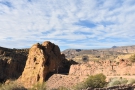 2
2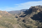 3
3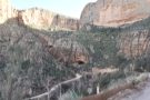 4
4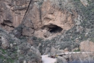 5
5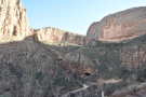 6
6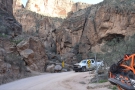 7
7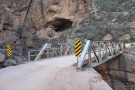 8
8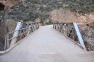 9
9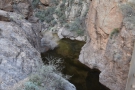 10
10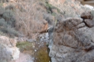 11
11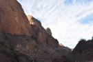 12
12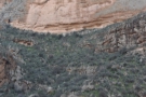 13
13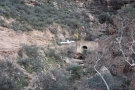 14
14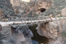 15
15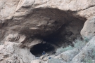 16
16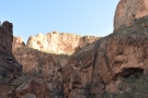 17
17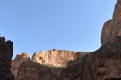 18
18 19
19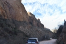 20
20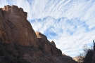 21
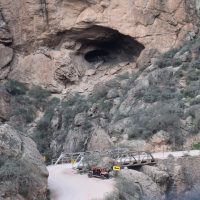
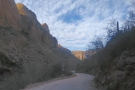
21The last time I was at Fish Creek Hill, I had stopped for a while, with enough time to walk out to the viewpoint beyond the carpark. This time around, I only made a brief stop before continuing along the Apache Trail as it descends the side of Fish Creek Canyon. Again, having stopped to admire the views on my previous drive, I stayed in the car this time, but I did drive just as gingerly along the unsurfaced road, aware of the sheer drop to my left, the narrowness of the road and the multiple blind bends. Making it safely to the bottom, I rounded the hairpin bend at the far end of the canyon, crossing Fish Creek in the process, and promptly pulled over. Having not had time to explore the area on my previous drive, I was eager to have a good look around.
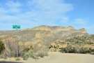
Standing there at the bottom of the canyon was amazing. At this point, Fish Creek Canyon is narrow, steep-sided, and several hundred meters deep although this is, ironically, one of its broadest parts! Overall, the canyon is 25 km long, running roughly northwest from the heart of the Superstition mountains to the Salt River.
The canyon extends about 15 km to the southeast from the point where the Apache Trail crosses Fish Creek, although in places its little more than a narrow fissure carved out by the water over thousands of years. From the bridge, Fish Creek flows north for a kilometre, the road following slightly to the east. The canyon briefly widens out where the Lewis and Prantry Creek flows in from the east.
The Apache Trail parts company with Fish Creek Canyon at this point, following the Lewis and Prantry Creek further east into the mountains. Meanwhile, Fish Creek carries on to the northwest for another 10 km, carving the northern section of Fish Creek Canyon through the rock until it drains into the Salt River just below the Horse Mesa Dam (which marks the end of Apache Lake).
I didn’t have very long to explore, certainly not long enough to do any hiking, although I believe that there are moderately difficult scrambles along the canyon to both north and south if you don’t mind clambering over boulders. Sadly, I didn’t even have time to walk along Fish Creek Canyon as far as the Lewis and Prantry Creek and back. Instead, I stayed by the bridge, marvelling at the feat of engineering that had led to its construction, and, more impressively, that of the road that descends the western canyon wall. You get some excellent views of the road from here, which only increased my admiration for the engineers who had built it.
A large cave lies almost directly above the bridge which, I suspect, provides some excellent views along the canyon to the north. Had I had more time, I would have scrambled up to explore, although there was already a large group of people inside (apparently, it’s a popular party spot). Reluctantly, I headed back to my car instead.
I’d like to return to Fish Creek Canyon at some point, and actually spend a decent amount of time (maybe half a day) there. Sadly that’s out of the question at the moment, since for the foreseeable future, the Apache Trail is closed between Tortilla Flat and Apache Lake (where I was going next).
You can see what I made of the drive to Apache Lake after the gallery.


.")

.")


 1
1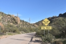 2
2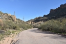 3
3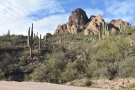 4
4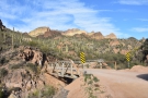 5
5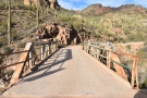 6
6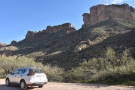 7
7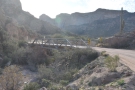 8
8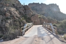 9
9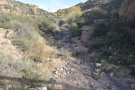 10
10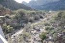 11
11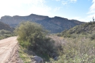 12
12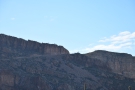 13
13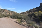 14
14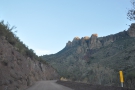 15
15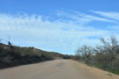 16
16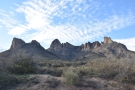 17
17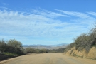 18
18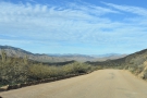 19
19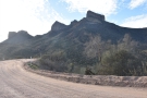 20
20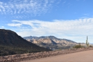 21
21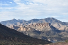 22
22 23
23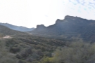 24
24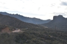 25
25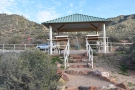 26
26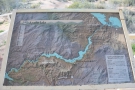 27
27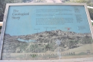 28
28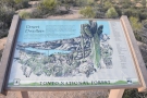 29
29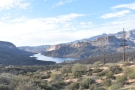 30
30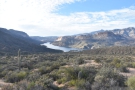 31
31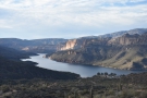 32
32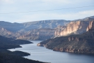 33
33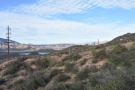 34
34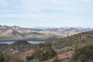 35
35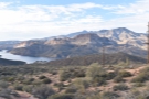 36
36 37
37After following Fish Creek Canyon north for about a kilometre, the valley opens out to the east, the Apache Trail parting company with Fish Creek as it swings east to follow the Lewis and Prantry Creek up into the mountains. This is the creek, by the way, that you can see from the Apache Trail as it rounds the top of Fish Creek Canyon.
When I drove this section of the Apache Trail in 2018, the sun was already setting, so I didn’t have time to stop. On this occasion, I was still making good time, setting off from the bottom of Fish Creek Canyon at 15:30, so I took my time, stopping at the narrow bridge over the Lewis and Prantry Creek, a semi-dry water course the valley of which the Apache Trail follows up into the mountains as it narrows and climbs. As always, I enjoyed being surrounded by mountains, particularly enjoying the view back down the valley and across to top of Fish Creek Canyon where you can see the Apache Trail rounding the headland before beginning its descent.
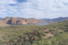
The Apache Trail emerges from the top of the valley into open land high above the Salt River, which is about a kilometre to the northwest, although at this point it’s actually Apache Lake, created by the construction of the Horse Mesa Dam in the 1920s. However, since the lake is long and thin, when you’re looking at it from up on the Apache Trail, it’s easy to mistake it for a wide section of the river!
An unpaved road branches off to the left just about the same time that you get your first views of the lake. This leads down to a fairly substantial marina and resort on the lake shore, although if you carry on along the Apache Trail for another kilometre, you’ll reach the Apache Lake Vista, which has a small car park, some information boards and excellent views of the lake and the amazing rock formations on the far side.
From there, a paved road leads straight down the mountainside to the marina and resort. Since it was only just gone four o’clock, after a brief stop at the vista to admire the views, I decided to take a detour down to the lake shore.
You can see what I made of Apache Lake after the gallery.


...")


 comes back into view...")


 1
1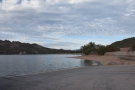 2
2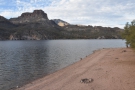 3
3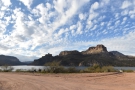 4
4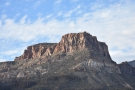 5
5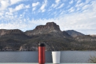 6
6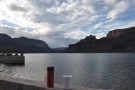 7
7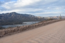 8
8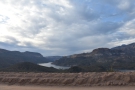 9
9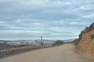 10
10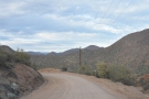 11
11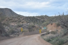 12
12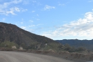 13
13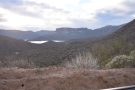 14
14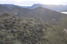 15
15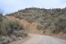 16
16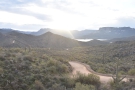 17
17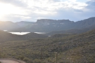 18
18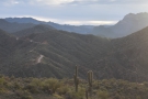 19
19 20
20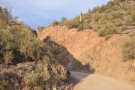 21
21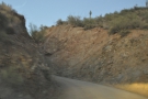 22
22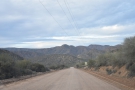 23
23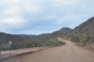 24
24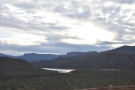 25
25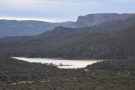 26
26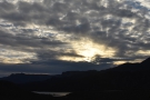 27
27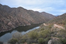 28
28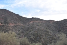 29
29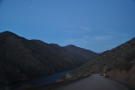 30
30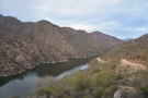 31
31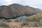 32
32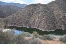 33
33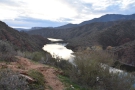 34
34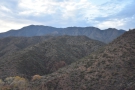 35
35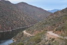 36
36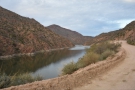 37
37 38
38After the unpaved Apache Trail, it made a pleasant change to be driving on tarmac again, even if the road from Apache Lake Vista to the shore is pretty steep and direct. It wasn’t quite as hair-raising as the descent into Fish Creek Canyon, but I took my time and didn’t take any photos.
I was there out of season, so largely had the place (and the massive car park) to myself. There’s quite a lot going on at Apache Lake, including a marina, three motels, a restaurant and a bar: it’s somewhere I wouldn’t mind staying for a couple of days and using as a base to explore the area.
On this occasion I stayed for about 15 minutes, long enough to wander down to the shore, admire the views and drink the coffee that I’d made that morning in my Travel Press before leaving my hotel. Then it was back to the car for the (steep) return drive up to the Apache Trail. If you have the time, it’s a detour worth taking, although if you are in a hurry, you might want to skip the drive down and back, instead taking in the amazing views from Apache Lake Vista. Alternatively, if you’ve got an hour or two, it would make a good lunch or dinner spot.
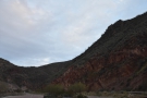
Back on the Apache Trail, I carried on upstream, towards the Theodore Roosevelt Dam, a drive I’d last done in the fading light the February before. This time I was determined to enjoy the views and take my time since it was only 16:45, giving me more than enough time to cover the 20 kilometres to the dam before nightfall as long as I didn’t stop too frequently!
As I mentioned the last time I drove the Apache Trail, from Apache Lake Vista, the road descends, straight and flat, roughly following the line of the lake/river, but just as you think you might be on the home stretch, it climbs again, twisting and turning as it cuts east to cross Davis Wash before heading northeast again, roughly parallel to the river, although this is now hidden from view by a range of peaks to your left.
The road descends to cross Pine Creek before climbing on the other side, where you get great views of both the river/lake and, looking back the way you’ve come, the Apache Trail itself. After more sharp twists and turns, the road emerges into more open country, descending on another long, straight section, passing the turning to the Burnt Corral Campground. Sadly, I didn’t have time to explore, but if you’re interested, it’s only a few hundred metres down to the Salt River (which, at this point, remains stubbornly out of view).
Once past the turning, another long, straight section takes you up towards the hills, where, looking back, the river comes into view (you can also see the road down to the Burnt Corral Campground). The Apache Trail has one final (literal) twist (well, a series of twists to be precise) as it descends towards the river, where you get some good views both up and downstream before the road drops right to the level of the water to run along the river’s edge at the bottom of the valley.
There’s a final climb, the road running along the top of small cliff right by the side of the river before it reaches the Theodore Roosevelt Dam and the end of the Apache Trail, which you can read about after the gallery.


 1
1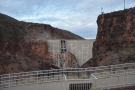 2
2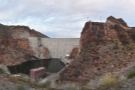 3
3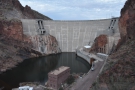 4
4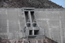 5
5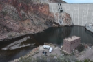 6
6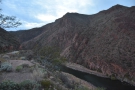 7
7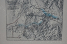 8
8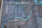 9
9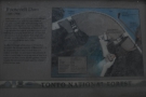 10
10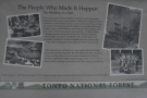 11
11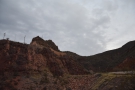 12
12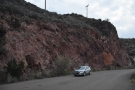 13
13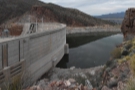 14
14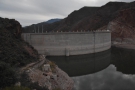 15
15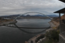 16
16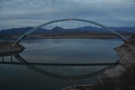 17
17As it makes its final approach to the Theodore Roosevelt Dam, the Apache Trail rounds a bend, where an access road drops away to the left, leading to the buildings at the base of the dam (this is off-limits to the public). Carrying on, you quickly come to the Theodore Roosevelt Dam Overlook, which has a large car park and multiple information boards. A walkway leads back along the side of the road to a further lookout which gives the best views of the rear side of the dam.
This is an impressive structure and, to my knowledge, is the only one of the four dams on the Salt River that you can get this close to (although, in fairness, I haven’t tried with the other three). Construction on the dam started in 1905, with the Apache Trail being built to provide access (this was long before SR 188 came into existence). The dam was completed in 1911, although it now looks very different to how it did back then.
This is thanks to a refurbishment and expansion which took place in the early 1990s. Completed in 1996, this raised the dam’s height from 86 metres to 109 metres and led to other changes, including the construction of the new Roosevelt Lake Bridge to take SR 188 across the mouth of the Salt River on the other side of the dam. Before that, the road came into the valley and across the top of the dam, which must have been an interesting drive!
From the car park, the Apache Trail climbs up via a horseshoe loop that runs east into a valley then back up the other side to a headland level with the (new) top of the dam. About 100 metres after this, there’s an overlook with a small car park on the left, providing great views of the front of the dam (where you can see the original top of the dam and the remains of the old road). Looking the other way, you also get great views of the new Roosevelt Lake Bridge.
From here, the Apache Trail continues a short way along the side of the lake before swinging around to join the (new) SR 188. Technically only SR 88 comes to an end at this point, SR 188 picking up the name “Apache Trail” all the way to its junction with US 60 just north of Globe, which is where I ended my driving that day (you can read about the drive south along SR 188 from when I did it the year before as part of my Big Loop).
However, as far as I’m concerned, the Apache Trail ends at the Theodore Roosevelt Dam, where I arrived at 17:30. In all, including multiple stops, it had taken me just over four hours to drive the roughly 60 kilometres along the Apache Trail (and, in fairness, I could have taken longer and more frequent stops). It’s an amazing road which I would love to drive again, once the middle section has been re-opened (and next time I will go from east to west for once). Until then, you can still reach Apache Lake at the trail’s eastern end, and Canyon Lake to the west, both of which are well worth the drive alone!
This concludes the third and final instalment of my Apache Trail Travel Spots. I hope you have enjoyed them and that I’ve inspired you to visit the area if you can.
If you liked this post, please let me know by clicking the “Like” button. If you have a WordPress account and you don’t mind everyone knowing that you liked this post, you can use the “Like this” button right at the bottom instead. [bawlu_buttons]
Don’t forget that you can share this post with your friends using buttons below.