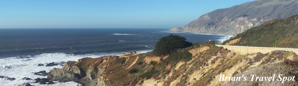
 Welcome to the fourth part of The Grand Adventure, my week-long drive from Phoenix to San Francisco, which I made in January 2017. I went from Phoenix to Joshua Tree National Park, spend a day hiking there, then drove to Los Angeles. After a day in the city, I took the Pacific Coast Highway to San Simeon, where I spent another day, this time visiting Hearst Castle. I had planned to carry on up the coast, through the Big Sur, to Santa Cruz and from there to San Francisco, but winter storms had washed out the road.
This led to a sudden change of plan. Instead of driving through the Big Sur, I doubled back on myself, cutting over the Santa Lucia Mountains on SR 46, before picking up my old friend US 101 for the drive north through the Salinas Valley on the other side of the Santa Lucia range. However, I was determined to see something of the Big Sur, so rather than carry on north to Santa Cruz, I doubled back on myself at Salinas, driving south down the Big Sur as far as I could go before turning around and heading up to Santa Cruz.
As usual, I’ve split this post into several parts:
- the Grand Detour (driving SR 46 over the Santa Lucia Mountains)
- but first, coffee (Acme Coffee Roasting Company and northern Big Sur)
- driving south (exploring Big Sur and stopping everywhere to admire the views)
- the drive back (retracing my steps, with more stops, and more coffee)
You can see how I got on, starting with my drive along SR 46, after the gallery.

 for breakfast.")


 1
1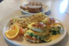 2
2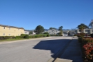 3
3 4
4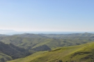 5
5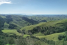 6
6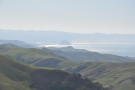 7
7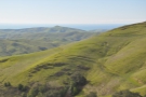 8
8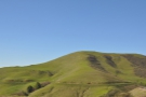 9
9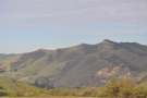 10
10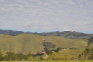 11
11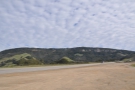 12
12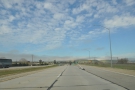 13
13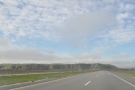 14
14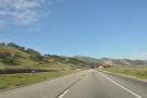 15
15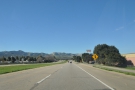 16
16After another late night spent sitting outside in the cold, uploading the following day’s Coffee Spot (Go Get Em Tiger, which I’d visited in Los Angeles that Monday), I got a decent night’s sleep. The following morning, I packed up my things and said goodbye (good riddance?) to the Day’s Inn.
Although the hotel had a free breakfast, this was no more than toast and cereal and I wanted something more substantial before my long drive. Instead, I headed over to the Big Sur restaurant, having spotted the breakfast menu when I was there for dinner on my first night in San Simeon. I went for my all-time diner favourite, Eggs Florentine, with a side order of toast, which set me up very nicely for the day ahead.
Then I was on my way again, driving a short way south along the coast before cutting inland and over the Santa Lucia Mountains on SR 46. As much as I missed driving the Big Sur, the climb up SR 46 was spectacular and, as I neared the top, I pulled over to admire the views before carrying on. The drive over the rest of the mountains was just as spectacular and, about half an hour later, I was dropping down on the other side, joining US 101 just south of Paso Robles in the Salinas Valley.
From there, US 101 heads north, following the bottom of the valley as it broadens out, running parallel to the train tracks, a route I was to take two years later when I caught the train from Los Angeles to San Jose. This had crossed the Santa Lucia Mountains further south at San Luis Obispo, climbing up the hills via a series of dramatic switchbacks.
The drive through the valley was pleasant enough, with the Santa Lucia range to the west and the Gablian range to the east, but it was very tedious, with the road running straight and true, offering few distractions. I much preferred doing the same route on the train, when I was able to sit and watch the landscape roll by without the tedium of having to keep a car on the road!
I said goodbye to US 101 for good at Salinas, at the northern end of the valley, turning left onto SR 68, following signposts for Monterey, where I was to re-join the Pacific Coast Highway for my exploration of the northern part of the Big Sur. However, before I did that, I had a short diversion to take.
You can find out where I went after the gallery.


.")


.")


 1
1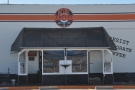 2
2 3
3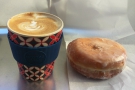 4
4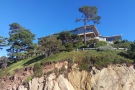 5
5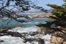 6
6 7
7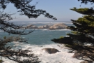 8
8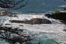 9
9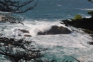 10
10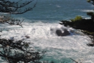 11
11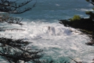 12
12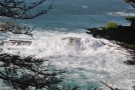 13
13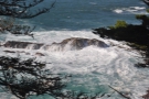 14
14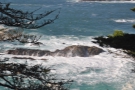 15
15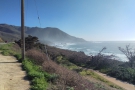 16
16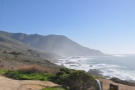 17
17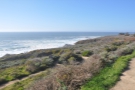 18
18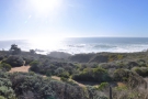 19
19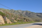 20
20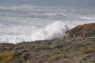 21
21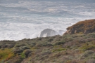 22
22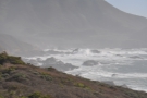 23
23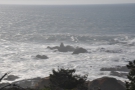 24
24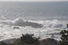 25
25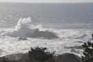 26
26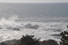 27
27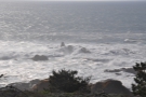 28
28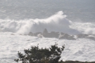 29
29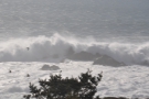 30
30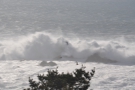 31
31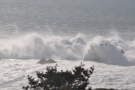 32
32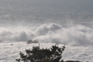 33
33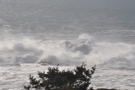 34
34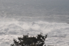 35
35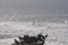 36
36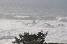 37
37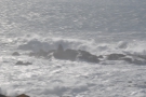 38
38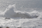 39
39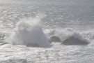 40
40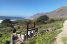 41
41 42
42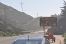 43
43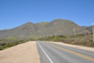 44
44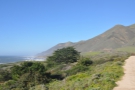 45
45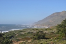 46
46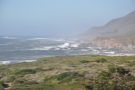 47
47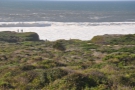 48
48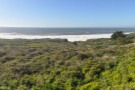 49
49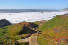 50
50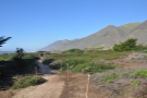 51
51 52
52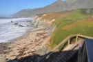 53
53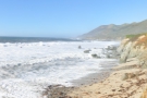 54
54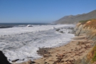 55
55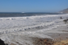 56
56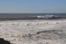 57
57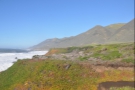 58
58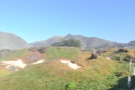 59
59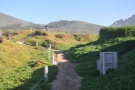 60
60It was on this trip that I made friends with Karen, who had suddenly appeared on my Instagram feed, liking my posts and offering coffee shops suggestions. I found this rather puzzling since, on checking her feed, it was obvious that Karen was in my hometown of Guildford, so what was she doing recommending Californian coffee shops? The answer, I discovered, was that she had grown up in the area, but was in Guildford, studying for an MSc at the University of Surrey (sadly, long before the days of The Hideout).
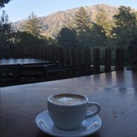
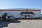
Not that I knew any of this at the time, but I was keen to try the first of Karen’s recommendations, the Acme Coffee Roasting Company in the wonderfully-named town of Seaside, just along the coast from Monterey. It took some finding though, tucked away just off the highway, and, I must confess, I did a double-take when I pulled into a parking lot, finding Acme at the back, occupying in a low-slung building, looking for all the world like a garage.
However, Karen hadn’t let me down, and I enjoyed my first speciality coffee (in a coffee shop) since leaving Los Angeles two days before. I’d have loved to have stayed longer, but the Big Sur was calling, so I was off again, re-joining the Pacific Coast Highway which sped me past Monterey and Carmel-by-the-Sea before hitting the coast at Carmel Highlands, where I made my first (brief) stop to watch the waves pounding on the rocks below.
Then I was off again, heading south along the amazing road, which hugged the mountainside high above the Pacific Ocean. I crossed Malpaso Creek, widely considered to be the northern boundary of the Big Sur, before stopping at a small turnout at Shoal Cavern to admire some more stunning scenery.
My plan was to drive as far south as the road would allow me before turning around and coming back north, ideally leaving the Big Sur at around sunset. I’d reached Carmel Highlands not long after two o’clock, so that, I figured, gave me about two hours to drive south, with roughly the same time to drive back. Give that it takes about two hours (without traffic), to drive from Carmel Highlands to the southern end of the Big Sur at Ragged Point (where I’d been the day before), I decided I had time for one or two stops, so pulled in at another small turnout at Garrapata State Park , where the Bluff Trail took me down to the beach (well, it would have done if the steps down to the beach itself weren’t taped off!).
Had I had longer, I could have explored further, since there were plenty of trails, either heading along the coast or up into the hills, but as I was, I was soon on my way again.
You can find out how far south along the Big Sur I got after the gallery.


 to north (right).")


 1
1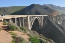 2
2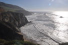 3
3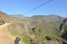 4
4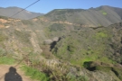 5
5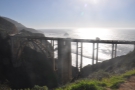 6
6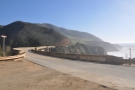 7
7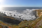 8
8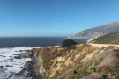 9
9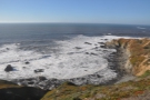 10
10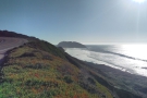 11
11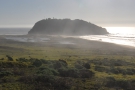 12
12 13
13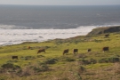 14
14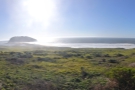 15
15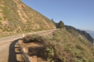 16
16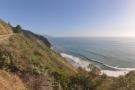 17
17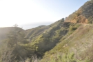 18
18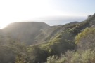 19
19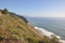 20
20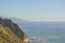 21
21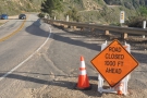 22
22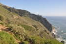 23
23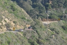 24
24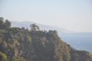 25
25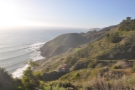 26
26 27
27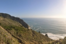 28
28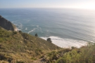 29
29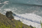 30
30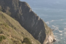 31
31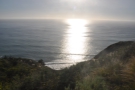 32
32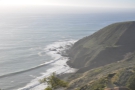 33
33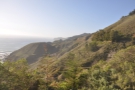 34
34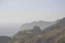 35
35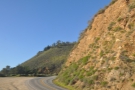 36
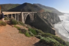
36After Garrapata State Park, my next stop was Bixby Creek Bridge, about four miles to the south. This iconic structure made a huge difference to the area when it opened in 1932, vaulting over the mouth of Bixby Creek in a wonderful feat of engineering. Before the bridge (and the accompanying section of the new coast road) was built, travelling north to south involved a 10-mile detour inland through the mountains along the Old Coast Road (these days no more than a track), which emerged near what is now the Andrew Molera State Park.
From the bridge, I carried on, crossing the Little Sur River and stopping on another turnout to admire the views. From there, I could see Point Sur, a large, rocky headland, attached to the rest of the coast by a low, narrow causeway and topped by a lighthouse which is open to the public at the weekends.
As it approaches Point Sur, the road cuts inland, passing through the Andrew Molera State Park, before following the Big Sur River upstream through a heavily wooded valley. After about 10 miles, the road emerges from the top of the valley, crossing a ridge before coming out high above the Pacific Ocean, where I stopped shortly after crossing Castro Canyon. This vantage point afforded some spectacular views along the coast to the south, although I could do little more than look, since at that point I was approaching the road closure.
Sure enough, five minutes later I passed a turnout with a sign reading “Road Closed 1000 Feet Ahead”. Rather than make a nuisance of myself, I pulled in at that point, turning the car around ready for the drive back up the Big Sur. From the turnout, I could see the roadblock up ahead, which, unlike the one I had encountered at the southern end of the Big Sur the day before, was backed up by a police car to deter over-enthusiastic tourists.
From Carmel Highlands to the turnout was a distance of just under 30 miles, but with all my stops, it had taken me an hour and a half to drive down there. And, of course, I had to drive all the way back (with, inevitably, more stops), something which I wanted to do in daylight. Since it was already four o’clock, and sunset was around half past five, I took a last look around before setting off back along the coast.
You can see what I got up to on my drive back up the Big Sur after the gallery.


 station, although I'd filled up in Seaside before I drove down...")
.")


")


.")


 a little way upstream which gave me this view.")


 1
1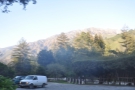 2
2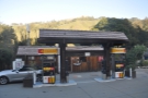 3
3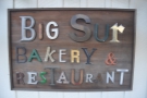 4
4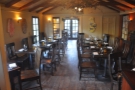 5
5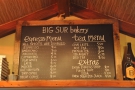 6
6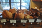 7
7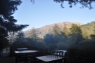 8
8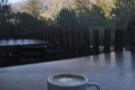 9
9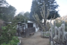 10
10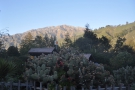 11
11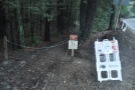 12
12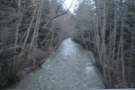 13
13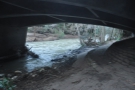 14
14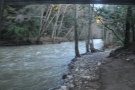 15
15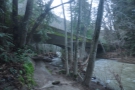 16
16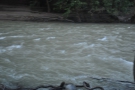 17
17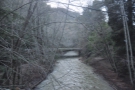 18
18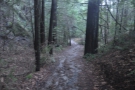 19
19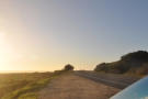 20
20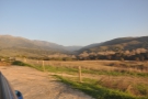 21
21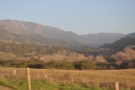 22
22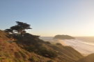 23
23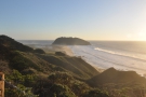 24
24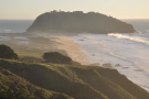 25
25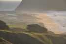 26
26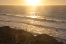 27
27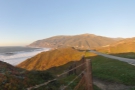 28
28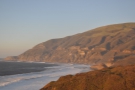 29
29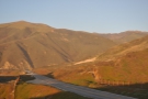 30
30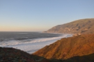 31
31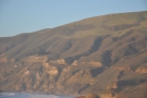 32
32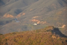 33
33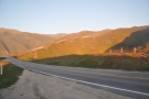 34
34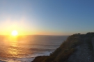 35
35 36
36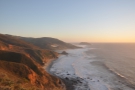 37
37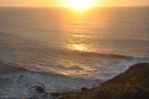 38
38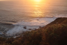 39
39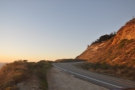 40
40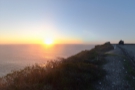 41
41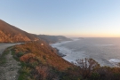 42
42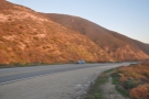 43
43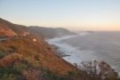 44
44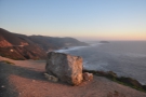 45
45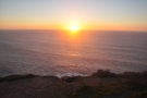 46
46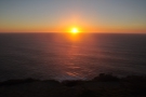 47
47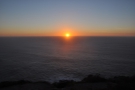 48
48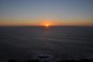 49
49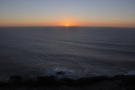 50
50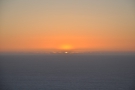 51
51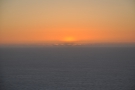 52
52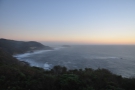 53
53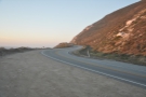 54
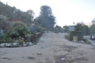
54My first stop on the way back was less to do with admiring the views and more to do with life’s essentials, namely coffee. On my way down, as I’d passed through the valley of the Big Sur River, I’d passed the Big Sur Bakery. The folks at the Acme Coffee Roasting Company had told me about it and since I had a little time to spare on my way back, I called in for a quick coffee.
The bakery serves a standard espresso-based menu using Acme’s coffee although, unusually, the menu included a flat white, so I had to order one. You can sit inside if you like (there’s also a restaurant area), but I went out to the patio where my coffee and I admired the late afternoon sunshine on the tops of the Santa Lucia Mountains on the far side of the valley.
On another day, I might have stopped for longer or had something to eat, but I pressed on, driving down the valley, following the Big Sur River, where I made my second stop. Up until now, I’d concentrated on the stunning coastline, but I also love forests and mountains, so decided to get out for a short walk in the valley, just where the road crossed the Big Sur River.
There are a number of trails in the area, although they were closed due to the recent rain (and, alarmingly, there was a notice about aggressive mountain lion activity in the area). However, it didn’t really affect me since wasn’t staying for long, just rambling up the river (which was really swollen from the rain) and back down the trail. One day I hope to be back for an extended stay.
After that, I drove out of the valley, through Andrew Molera State Park, where I stopped yet again, this time to look back at the mountains (which I’d seen, but not photographed, on my way down). This pattern of driving for a few minutes then having to pull over to admire the views continued, with brief stops just north of Point Sur (close to where I pulled over on the way down), south of the Little Sur River and at the Big Sur turnout just beyond that.
My final stop came a few minutes later, a couple of miles south of Bixby Creek Bridge, at the delightfully named Sea Otter Refuge Point, where I pulled over to watch the sunset. It was the fourth consecutive day I’d seen the sun sink into the Pacific Ocean and, with little cloud around, it was the clearest (and least spectacular) of them all!
From there, I drove nonstop until I reached Monterey, although I was constantly admiring the views in the twilight. I had originally planned to carry on driving until I reached Santa Cruz, but that was another 45 minutes away and, since I’d be doing it in the dark anyway, I decided to stop in Monterey for dinner before carrying on with my journey.
So that concludes Part IV of The Grand Adventure. You can see how the adventure ended in the last instalment of The Grand Adventure, which recounts my final day, driving into downtown San Francisco on a Friday afternoon (which, with hindsight, wasn’t a very good idea!).
If you liked this post, please let me know by clicking the “Like” button. If you have a WordPress account and you don’t mind everyone knowing that you liked this post, you can use the “Like this” button right at the bottom instead. [bawlu_buttons]
Don’t forget that you can share this post with your friends using buttons below.